National Trust Database - Search Results |
Back to search page » | |
| Displaying 1- 10 of 11 records found |
| Image | Name | Detail | File number | Level |
|---|---|---|---|---|
|
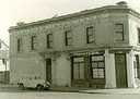
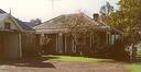
Burgess House
166 Bay Street,, BRIGHTON VIC 3186 - Property No B0496 |
Classified: 17/04/1975 |
B0496 |
Local |
|
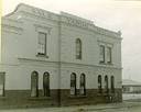
St Andrews Brighton Cemetery
N.E. Cnr New & Church Streets,, BRIGHTON VIC 3186 - Property No B6817 |
With more than 300 burials, most of them before 1860, St Andrew's Cemetery is a rare Victorian example of a traditional English parish church with its private graveyard. It is of state significance for the following reasons: -- Its importance in the course of Australia's cultural history as a sophisticated and substantially intact example of a suburban churchyard burial ground, exhibiting unusual cultural features associated with the development of suburban churchyard burial ... more |
B6817 |
State | |
|
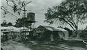
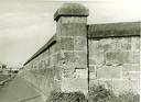
Former Newmarket Saleyards And Abattoirs
Smithfield Road,, KENSINGTON VIC 3031 - Property No B5379 |
Site No 3 Stockyards and stock bridge over Racecourse Road. Site No 4 Newmarket saleyards administration building and clock tower; drovers hut; adjacent saleyards to east and south of administration building. Site No 5 City abattoirs area outlined in red; includes workers' meeting hall with seating and other fixtures; stock routes throughout the saleyards and abattoirs and the stock bridge over the Maribyrnong. Site No 10 Angliss meatworks - stock route along the west bank ... more |
B5379 |
State |
|
Chaumont
BATESFORD VIC 3221 - Property No B5101 |
B5101 |
File only | |
|
77 Church Street,, GEELONG WEST VIC 3218 - Property No B0271 |
B0271 |
File only | |
|
Graveyard - Holy Trinity Anglican Church
Gisborne Road, BACCHUS MARSH VIC 3340 - Property No B2726 |
B2726 |
File only | ||
|
Neuchatel Vineyard
Cnr Barrabool & Merrawarp Roads,, BARRABOOL VIC 3221 - Property No B3730 |
B3730 |
File only | |
|
Kepler Street, WARRNAMBOOL VIC 3280 - Property No B2823 |
B2823 |
File only | |
|
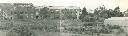
Jam Jerrup Point
JAM JERRUP VIC 3984 - Property No L10079 |
Red Bluff is the highest point of an eroding cliffed coast which slopes south to Stockyard or Passage Point, a cuspate foreland formed by a succession of curved sandy beach ridges enclosing swampy tracts between them. The area was important in the pastoral era of settlement and stock from Red Bluff Station were shipped from the Point. The eroding cliffs consist of Upper Tertiary ferruginous sandstones with mottled clay and a soil horizon above. Sand from the ... more |
L10079 |
Local | |
|
Sand Ridge Track, Barmah State Forest,, BARMAH VIC 3639 - Property No B0712 |
This place is not yet classified by the Trust, but may be in the future. It is however listed at the State level by the State Government body Heritage Victoria, giving it statutory protection. Details can be found at www.heritage.vic.gov.au, by clicking on the Heritage Register Online, and searching using the "H" number given above. |
B0712 |
File only |
| 1 2 | next |
