National Trust Database - Search Results |
Back to search page » | |
| Displaying 1- 2 of 2 records found |
| Image | Name | Detail | File number | Level |
|---|---|---|---|---|
|
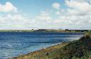
CAMPERDOWN VIC 3260 - Property No L10298 |
Lake Purrumbete is a maar, a broad, shallow volcanic crater formed by an explosive eruption, probably during the Pliocene period. Much of the material ejected was ash or scoria (fragments of basalt rock), which fell nearby to form a raised rim around the crater, particularly on the eastern, or downwind, side. The crater has subsequently partly filled with water to form a lake of fresh water. Around the lake almost all the natural vegetation has ... more |
L10298 |
State |
|
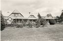
3551 Princes Highway,, WEERITE VIC 3260 - Property No B0733 |
The pastoral run Purrumbete was established in December 1838 by John and Peter Manifold following earlier attempts at settlement near Geelong (1836-38) and Van Diemen's Land (1831-36). The first slab hut at Purrumbete was replaced in 1842 with a primitive bluestone and weatherboard house later integrated into a larger building of the 1850s and finally extensively remodelled and extended in 1901 by architect Guyon Purchas, with Art Nouveau carving by Robert Prensel. ... more |
B0733 |
State |
| 1 |
