National Trust Database - Search Results |
Back to search page » | |
| Displaying 1- 10 of 24 records found |
| Image | Name | Detail | File number | Level |
|---|---|---|---|---|
|
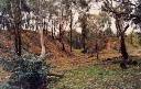
Mt Tarrengower And Nuggetty Ranges
MALDON VIC 3463 - Property No L10136 |
The Mt Tarrengower, Nuggetty Ranges and Peg Leg-Porcupine Diggings area is of State significance because of its landscape quality, cultural associations and botanical interest. The ranges viewed from Maldon form a striking backdrop for the town and emphasize the strong cultural relationship between the township and the landscape. Vegetation cover varies from open woodland with natural grassy openings to regrowth coppice forest on turned-over soil. Of particular ... more |
L10136 |
State |
|
VIC - Property No L10192 |
L10192 |
File only | ||
|
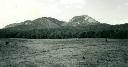
MOUNT BUFFALO VIC 3740 - Property No L10221 |
This landscape is of a) very high visual quality from which the man-made alterations have detracted only slightly b) high scientific interest due to the diversity of the plant communities (which include three endemic species) and also the evidence the plateau provides of geomorphological processes. c) high cultural interest in all historical, educational and recreational aspects. Classified 11/04/1983. |
L10221 |
State |
|
POREPUNKAH VIC 3740 - Property No L10223 |
The panoramic views, from one of Australia's most outstanding elevated viewing points, encompasses bold mountain ranges and lush valley floors. The Australian Alps, including Mounts Buffalo, Bogong and Feathertop, may be seen in the distance to the south. Classified 05/04/1976. |
L10223 |
Regional | |
|
Upper Snowy River - Mt Tingaringy
BONANG VIC 3888 - Property No L10254 |
The Upper Snowy-Tingaringy Region is of outstanding conservation value as the most extensive and intact rainshadow area in East Gippsland. Associated botanical and zoological values are of State significance. Catchment and landform values are high and outstanding scenic and landscape quality further enhance the significance of the region. |
L10254 |
State | |
|
Jacksons Road, MOUNT ELIZA VIC 3930 - Property No B1534 |
Classified: 17/01/1963 |
B1534 |
File only |
|
VIC - Property No L10257 |
The Mt Kaye-Mt Coompracambra Region is of national botanical significance due to its species and bio-geographic diversity, and to the large number of rare, endangered restricted or otherwise significant species or communities. The Genoa River Valley is possibly of international significance because of the archaeological evidence contained in geological exposures, and displays geomorphological features of national importance. Catchment and land system values are of at least State ... more |
L10257 |
State | |

|
Hare Krishna Australian Headquarters
197 Danks Street,, ALBERT PARK VIC 3206 - Property No B0850 |
Built c. 1880. Classified: 30/10/1958 |
B0850 |
Local |
|
Ballarat Buninyong Road, MOUNT CLEAR VIC 3350 - Property No B2749 |
Demolished: 1970 |
B2749 |
Demolished | |

|
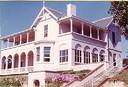
985 Little River Road, LITTLE RIVER VIC 3211 - Property No B1726 |
Mt Rothwell Homestead, Little River, was constructed for Pastoralist Robert Chirnside after 1871 to the designs, it is understood, of Architect P Colquhuoun. Chirnside came to Victoria in 1857 to manage the Werribee run for his uncle Thomas Chirnside and bought the Mount Rothwell land in 1865. The large, single storeyed bluestone homestead, possibly built in stages, is asymmetrically composed with a projecting wing and bay window. There is a finely detailed cast iron ... more |
B1726 |
State |
| 1 2 3 | next |
