National Trust Database - Search Results |
Back to search page » | |
| Displaying 1- 9 of 9 records found |
| Image | Name | Detail | File number | Level |
|---|---|---|---|---|
|
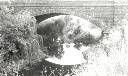
Bluestone Bridge over Merri Creek
Newlands Road (South side),, COBURG VIC 3058 - Property No B0942 |
Classified: 20/11/1958 Revised: 03/08/1998 |
B0942 |
State |
|
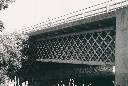
Bell Street Bridge over Merri Creek
Bell Street,, COBURG VIC 3058 - Property No B7474 |
B7474 |
File only | |
|
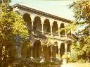
43 Sackville Street, KEW VIC 3101 - Property No B3186 |
A fine example of a double storey colonnaded mansion with a well proportioned facade and high quality external details. Classified: 13/09/1973 |
B3186 |
Local |
|
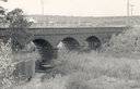
Bluestone Bridge over Merri Creek
Murray Road,, COBURG VIC 3058 - Property No B0941 |
This buuestone arch bridge, built in 1870, has a single main span of 25.9 metres, this being either the fourth or fifth large stone arch span ever built in Australia. It was exceeded by Lansdowne (1836, 26.7 metres), Parramatta (1839, 27.4 metres), and the first Princes Bridge, Melbourne (1850, 45.7 metres). There is also another large span stone arch across Merri Creek in Heidelberg Road (possibly 1867), which may be larger. Together with the adjacent Newlands Road Bridge it ... more |
B0941 |
State |

|
1 Merrimu Lane,, SHERBROOKE VIC 3789 - Property No B6780 |
A timber cottage, the original section of which was built in 1893 by Robert W Graham, is of local historical significance, Merrimu is historically significant as the original post office in the Sherbrooke area and for its associations with the Graham family, prominent pioneers who were the centre of the community. From Merrimu, Robert W Graham, described as 'the Father of Sherbrooke', provided all official services, and in particular was the Postmaster for nearly twenty-five ... more |
B6780 |
Local |
|
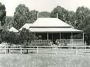
6 Merriang Homestead Road ,, MYRTLEFORD VIC 3737 - Property No B4362 |
Merriang is a precisely modelled, single-storied building. Facing east, the facade is delineated by a verandah, with binding returns to north and south and balustraded cast-iron panels. Foundations, lintels and verandah steps are boldly expressed in dressed blocks of granite. Walls are of brick, made on the property; the outer walls of three brick thickness. Roofing is of galvanised iron, over shingles. A wide and high entrance hall passes family living areas, with doors of New ... more |
B4362 |
Local |
|
Former Merrigum Butter Factory & Farmers' Frozen Produce Co.
Judd Street,, MERRIGUM VIC 3618 - Property No B6335 |
B6335 |
File only | |
|
Former Royal Merrijig Inn - Port Fairy - Historic Area
Merrijig Inn
1 Campbell Street,, PORT FAIRY VIC 3284 - Property No B764 |
The Merrijig Inn was constructed in 1844 and was de-licensed in 1852 and subsequently purchased by the government for police offices. Courts sat there until 1860 and it also housed the officers of the Belfast District Road Board (from 1853) and the municipality of Belfast (from 1856-58). The two-storied section in Campbell Street was demolished c.1900 and the material was used to build shops at 62-64 Sackville Street. The Merrijig Inn is one of the oldest surviving ... more |
B0764 |
State |
|
Lake Bullen Merri and Lake Gnotuk
CAMPERDOWN VIC 3260 - Property No L10270 |
File note 31/05/2012: Now incorporates L10285 (Lake Bullen Merri / Lake Gnotuk Advisory Committee), and L10292 (Lake Gnotuk). Lake Bullen Merri is a maar, a broad volcanic crater formed by one or more major volcanic explosions during the late Tertiary period. Much of the ash and scoria ejected during the explosions fell nearby to create a raised rim around the crater. Within the crater, water has accumulated to form a brackish lake. Around the lake the native vegetation ... more |
L10270 |
National |
| 1 |
