| Back to search results » | Back to search page » |
|
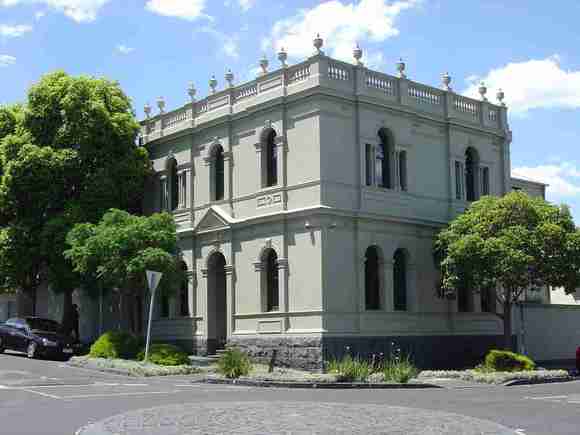
HOWLANDS or Alexander's house
Location37 Docker Street, RICHMOND VIC 3121 - Property No 188405 LevelIncl in HO area indiv sig |
|


Statement of Significance
This site is subject to a Statement of Significance for the building, as
well as a Statement of Significance for the Precinct in which it is
located.
Please find below the Statement for the building, followed by the
Statement for the Precinct.
Individual place statement of significance:
Richmond Conservation Study, Volume 2
Precinct statement of significance
Component streets include:
Alban Street, Alfred Street, Allowah Terrace, Berry Street,
Botherambo Street, Brock Place, Carroll Street, Clifton Street, Dando
Street, Darlington Parade, Derby Street, Dickmann Street, Docker
Street, Eucalyptus Street, Fear Street, Firebell Lane, Fordham Court,
Gipps Street, Goodwood Street, Grattan Place, Hodgson Terrace, King
Street, Lennox Street, Little Alfred Street, Loughnan Street, Margaret
Street, Miles Street, Miller Street, Montgomery Street, Mulberry
Street, Portland Street, Punt Road, Richmond Terrace, Rogers Street,
Rotherwood Street, Rowena Parade, Sherwood Street, Stanley Street,
Stewart Place, Stewart Street, Strode Place, Strode Street, Sutton
Grove, Swan Street, Tanner Street, Tennyson Street, The Crofts, The
Vaucluse, Tyson Street, Union Street, Verity Street, Waltham Place,
Waltham Street, Wangaratta Street, Waverley Street, Woodlawn Street
Proposed sub-areas
The previous analyses of this Heritage Overlay Area have all noted
its diversity but this `diversity' is formed within the following
distinct sub-areas that are defined by the street pattern and building stock.
A. Richmond Hill Heritage Overlay Area (West Sub-area):
The area is set out on an irregular plan, as an accumulation of small
private subdivisions, diverse lot sizes, and small cottage
development. The Richmond Hill West Sub-area is generally bordered on
the south by Tanner St, on the west by Punt Rd, on the north by the
back of properties facing Bridge Rd, and on the east by Lennox St, the
backs of properties facing Lennox St and Wangaratta Street.
B. Richmond Hill Heritage Overlay Area (North Sub-area):
This is an area of large villas on large irregularly planned
allotments, sited on the side of Richmond Hill, and adjoining
significant religious complexes facing Church St (see HO315 Church
Street Heritage Overlay Area, Richmond). It is generally bounded on
the south by the Richmond Terrace service lane; on the west by Lennox
St and the rear of properties facing Lennox St; on the north by the
rear of properties facing Bridge Rd and on the east by the rear of
properties facing Church St.
C. Pelaco complex, Fordham Court/Goodwood Street Sub-area
Set within the Richmond Hill Heritage Overlay Area North Sub-area,
the sub area includes the inter-war residential Fordham Court and
associated part of the Goodwood St area, and the contemporary Pelaco
industrial complex opposite, as once part of the Pelaco land holding.
The residential parts of this sub-area have a homogenous residential
character and subdivision pattern.
D. Richmond Hill Heritage Overlay Area (South Residential or
Clifton Village Sub-area):
This sub-area is demarcated by the Reverend Docker's `Clifton
Village' standard grid plan, with large and small intermediate service
streets. It originally had small regularly sized urban allotments and
small early Victorian-era cottage development. The sub-area is
generally bordered by Wangaratta St on the west, Montgomery St and the
Richmond Terrace service lane on the north, and the rear of properties
facing Church St on the east and Swan Street on the south.
E. Richmond Hill Heritage Overlay Area (South Industrial Sub-area)
This sub-area is generally demarcated by the large irregular
allotments and early 20th century industrial development at the south
west corner of the Richmond Hill Heritage Overlay Area. It is bordered
by the railway on the south, the Stewart St service lane on the west,
Tanner St on the north and Wangaratta St on the east.
STATEMENT OF SIGNIFICANCE
ALL SUB-PRECINCTS
What is significant?
Subdivision types
The land which now comprises the Richmond Hill Area was purchased
from the Crown in 1839 and consisted of six portions each of 25 acres
in the parish of Jika Jika (CPs 21-26). The purchasers were Dr.
Farquhar McCrae (CP24, surgeon), Rev. Joseph Docker (CP21-22,
squatter), W H Yaldwyn (CP26, squatter, banker), Henry Gordon Brock
(CP25), and John McNall (CP23, Melbourne's first butcher) (96). From 1840 onwards, Dr. McCrae sold
parts of his allotment (at the north west corner of the heritage
overlay) to prominent Melbourne figures, including Alexander McCrae ,
Alfred Woolley, Charles Williams, George Arden, and Thomas Strode
(proprietors of the Port Phillip Gazette).(97) He also
subdivided off 36 half acre blocks, creating Rowena Parade, Sherwood
and Rotherwood Streets. Further subdivisions took place in the 1870s
and 1880s. Yaldwyn sold his allotment (at the north-east corner of the heritage
overlay) to William Meek in 1840 and, by 1853, the Waltham Street and
Darlington Parade areas were subdivided, and further subdivided in the
1880s. The Vaucluse area was laid out in the 1860s and a private
street was created to link Rowena Parade and Church Street, for the
use of abutting landholders only. The Vaucluse, thought to be the only
Victorian-era private street in the inner suburbs, has its eastern
entry at St Ignatius Church. Large houses were erected on this
section, including Richmond Hill for James Henty (Waltham Street,
1851) and a two-storey Italianate house for distinguished architect,
James Blackburn Jr. Docker had subdivided his two allotments by 1853 (at the south-east
corner of the heritage overlay), creating a model village (Village of
Clifton) set out as 365 lots on a grid plan designed by Charles Laing.
Its regular layout was unlike the other haphazardly planned private
subdivisions in the area. The village was bordered by Wangaratta St
(inclusive) on the west, the Richmond Terrace service lane on the
north, the Church St on the east and Swan Street on the south (98). By
1857 Docker still owned many of the houses built on these allotments.
His own townhouse was at 370 Church Street. By the 1880s, this area
was almost fully developed. (See South Residential Sub-precinct)
Brock's allotment (at the north-centre of the heritage overlay) was
purchased by overlander John Gardiner (99) who erected a villa on it
when he retired from his grazing activities to take up the position of
managing director of the Port Phillip Bank in 1840.(100) By 1853,
Lennox Street, Rowena Parade and Goodwood Street had been laid out.
Further subdivisions occurred in the 1870s and 1880s. The allotment purchased by McNall (at the south-west corner of the
heritage overlay) had undergone minor subdivision by 1853. McNall
erected his house there, and his widow continued to live there
following his death in the 1850s. (101) In 1859, the railway was
established, and Richmond Station was constructed at the south-west
corner of the allotment. The land had undergone major subdivision by
the 1870s and 1880s.
Major industry development
In the early 20th century the expansion of manufacturing across the
nation was reflected in new industrial centres that were developed
close to rail and road transport, as distinct from the Victorian-era
industrial development that had occupied coastal sites or river and
creek banks. Near to the transport hub of Richmond Railway Station and
busy Punt Road, grew a distinctive group of factories and warehouses,
mainly associated with the growth of the clothing manufacturing
industry in the City and dating substantially from the early decades
of the 20th century. This area had previously been residential (102).
The Australian Knitting Mills Ltd. (41-43 Stewart St, knitted goods
manufacturers) complex was at the centre of the Stewart-Tanner Streets
industrial area development area. It was developed from 1912 when the
supply for World War One uniforms was an impetus for its expansion and
had another major building addition in 1922-5 (103). The company
created the `Golden Fleece' and `Kookaburra' brands.
Inter-war residential estates
Set away from this concentrated industrial strip, but related
historically to it, was the Pelaco factory (1922-1928), located on a
hill on the former site of a Victorian-era mansion. Houses in Fordham
Court and the associated part of Goodwood Street were built
speculatively in 1939 for Mrs B.E. Fordham of Yarradale Rd., Toorak,
on land sold by Pelaco (104). These houses provide a distinctive
enclave within the surrounding Victorian and Edwardian-era development.
A. RICHMOND HILL HERITAGE OVERLAY AREA (WEST SUB-AREA)
Main development era
The main development period evident in the Richmond Hill west
sub-area of the Heritage Overlay Area is that of the Victorian era
with a substantial contribution from the Edwardian-period. There is
also a contribution from some well preserved inter-war buildings and
individually significant places of all eras.
Contributory elements
The Heritage Overlay Area contributory elements include (but not
exclusively) mainly small, detached and some attached Victorian-era
and Edwardian-era houses having typically: . Pitched gabled or hipped roofs, with some facade parapets, . One storey wall heights but with some two storey house rows, . Face brick (red, dichrome and polychrome), weatherboard, or stucco walls; . Corrugated iron roof and slate cladding, some unglazed Marseilles
pattern terra-cotta tiles; . Chimneys of either stucco finish (with moulded caps) or of matching
face brickwork with corbelled capping courses; . Post-supported verandah elements facing the street, set out on two
levels as required with cast-iron detailing for Victorian-era houses
and typically timber for Edwardian-era; . Less than 40% of the street wall face comprised with openings such
as windows and doors; and . Small front gardens, originally bordered by typically timber picket
front fences of around 1m height. Contributory elements also include: . Corner shops and residences with display windows and zero boundary setbacks. . Well preserved buildings including typically one storey buildings
from the pre Second War era. . Public infrastructure, expressive of the Victorian and
Edwardian-eras such as bluestone pitched road paving, crossings, stone
kerbs, channels, and asphalt paved footpaths.
B RICHMOND HILL HERITAGE OVERLAY AREA (NORTH SUB-AREA)
Main development era
The main development period of the Richmond Hill north sub-area of
the Heritage Overlay Area is that of the Victorian-era with a
substantial contribution from the Edwardian-period. There is also a
contribution from some well preserved inter-war buildings and
individually significant places of all eras.
Contributory elements
The Heritage Overlay Area contributory elements include (but not
exclusively) mainly detached and some attached Victorian-era and
Edwardian-era mainly one and two-storey houses having typically: . Pitched gabled or hipped roofs, with some facade parapets, . One and two storey wall heights but with some two storey house rows, . Face brick (red, dichrome and polychrome), or stucco walls; . Corrugated iron roof and slate cladding, some Marseilles pattern
terracotta tiles; . Chimneys of either stucco finish (with moulded caps) or of matching
face brickwork with corbelled capping courses; . Post-supported verandah elements facing the street, set out on two
levels as required with cast-iron detailing for Victorian-era houses; . Less than 40% of the street wall face comprised with openings such
as windows and doors; and . Front gardens, originally bordered by typically timber or iron
picket front fences of around 1m height. Contributory elements also include: . Corner shops and residences with display windows and zero boundary setbacks. . Well preserved buildings including typically one storey buildings
from the pre Second War era. . Public infrastructure, expressive of the Victorian and
Edwardian-eras such as bluestone pitched road paving, crossings, stone
kerbs, channels, and asphalt paved footpaths.
C. RICHMOND HILL HERITAGE OVERLAY AREA (PELACO, FORDHAM COURT/PART
GOODWOOD STREET SUB-AREA)
Main development era
The main development period of the Richmond Hill Fordham
Court/Goodwood Street sub-area of the Heritage Overlay Area is that of
the Inter-war era.
Contributory elements
Contributory buildings in the Fordham Court/Goodwood Street sub-area
are typically: . Residential: . Single storey; . Constructed in brick and rendered masonry; . Of a hipped and gabled tiled roof form, some with a single hipped
or gabled roof form over the two dwellings to appear as single larger houses; . Semi detached duplexes; . Set in relatively deep garden setbacks; and . Fenced originally with front fences of low (500-700mm panel height)
brick and rendered masonry pier and panel walls.
And
. Public infrastructure, part expressive of the Victorian and
Edwardian-eras such as asphalt paved footpaths but most of the kerb
and channel is concrete, as typical of the inter-war period. . Former Pelaco factory (c1922) as an icon in the area, but unrelated
in scale and form to the inter-war housing nearby.
D. RICHMOND HILL HERITAGE OVERLAY AREA (SOUTH SUB-AREA)
Main development era
The main development period evident in south sub-area of the Richmond
Hill Heritage Overlay Area is that of the Victorian-era. There is also
a contribution from the Edwardian-era and some well preserved
inter-war buildings and individually significant places of all eras.
Contributory elements
The Heritage Overlay Area contributory elements include (but not
exclusively) mainly detached and some attached Victorian-era (some
early Victorian-era), one-storey houses having typically: . Steeply pitched gabled or hipped roofs; . One storey wall heights; . Weatherboard (square or bead edge), face brick (dichrome), stone,
or stucco walls; . Corrugated iron roof and slate cladding; . Chimneys of either stucco finish (with moulded caps) or of matching
face brickwork with corbelled capping courses; . Simple post-supported timber verandah elements facing the street; . Less than 40% of the street wall face comprised with openings such
as windows and doors; and . Front gardens, sometimes minimal, originally bordered by typically
timber picket front fences of around 1m height. Contributory elements also include: . Corner shops and residences with display windows and zero boundary setbacks; . Well preserved buildings, including typically one storey buildings
from the pre Second War era. . A regular subdivision plan with alternating wide principal streets
and narrow service streets; and . Public infrastructure, expressive of the Victorian and
Edwardian-eras such as bluestone pitched road paving, crossings, stone
kerbs, channels, and asphalt paved footpaths.
E. RICHMOND HILL HERITAGE OVERLAY AREA (SOUTH INDUSTRIAL SUB-AREA)
Main development era
Main development period in the Richmond Hill south industrial
sub-area of the Heritage Overlay Area is of the Edwardian-era and
inter-war period.
Contributory elements
Contributory elements include (but not exclusively) industrial
buildings from the early decades of the 20th century with typically: . Wall heights ranging from 1-5 levels; . Facade parapets, sometimes with proprietary logos, with pitched
roofs behind; . Limited or no setback from street frontages; and . Walls of face red brick (some over-painted) with rendered bands. Contributory elements also include: . Public infrastructure, part expressive of the Victorian and
Edwardian-eras such as some bluestone pitching and asphalt paved footpaths.
How is it significant?
HO332 Richmond Hill Heritage Overlay Area as a whole is
aesthetically and historically significant to the City of
Yarra (National Estate Register [NER]Criteria E1, A4)
Why is it significant?
A. The Richmond Hill Heritage Overlay Area (west sub-area)
The Richmond Hill Heritage Overlay Area (west sub-area) is significant: . As an illustration of a typical early private subdivision and
development in the City, shown by the irregular street patterns,
widely varying allotment sizes, and unusual house siting (onto lanes); . As one of the earliest private development areas in the City for
worker housing, dating from the 1840s, as expressed today by the many
early small cottages linked historically to developers who resided in
the more salubrious elevated parts of this area;
B. The Richmond Hill Heritage Overlay Area (north sub-area)
The Richmond Hill Heritage Overlay Area (north) is significant: . For the well preserved, well-situated and sometimes large Victorian
and Edwardian period houses and for the contribution of well preserved
buildings from the inter-war period and individually significant
buildings from all periods; . As one of the early private housing development areas for the
wealthy, evolving from the 1840s, and associated with some of
Melbourne's most prominent early settlers as seen in their gracious
residences, elevated siting and proximity to religious centres of most denominations; . As particularly indicative (like the west sub-area) of
Victorian-era private subdivision with irregular street patterns and
lot sizes, and one private road; and . For the views, from both inside and outside the area, to The
Vaucluse Convent, the church spires and towers of St Ignatius and the
utilitarian four storey red brick Pelaco factory, with its early neon
sign above.
C. The Richmond Hill Heritage Overlay Area (former Pelaco
factory, Fordham Court/Goodwood Street sub-area)
The Richmond Hill Heritage Overlay Area (Pelaco, Fordham
Court/Goodwood Street sub-area) is significant: . For the well preserved and visually cohesive groups of inter-war
and early post WW2 residential development . For the historical and visual links of this inter-war development
with the adjacent inter-war landmark Pelaco Factory; . For the contribution of the iconic Pelaco factory complex and
illuminated sign, that is well-preserved externally, large in scale
and set prominently on the hill as, historically, a symbol of
Richmond's special role in the development of key manufacturing
centres in the first half of the 20th century.
D. The Richmond Hill Heritage Overlay Area (south residential sub-area)
The Richmond Hill Heritage Overlay Area (south) is significant: . As one of the earliest private development areas in the City for
worker housing, dating initially from the 1840s but extending in the
gold-era of the 1850s, as early small cottages set on small allotments; . For the historical links of the street layout and subsequent
housing development with the Docker family and the estate's designer,
the noted architect and surveyor, Charles Laing; . As an illustration of a rare type of model private subdivision and
development in the Melbourne area in the form of a planned `village',
as shown by the regular street patterns, similar allotment sizes, and
the originally residential land use.
E. The Richmond Hill Heritage Overlay Area (south industrial sub-area)
The Richmond Hill Heritage Overlay Area (south industrial sub-area)
is significant: . As a distinctive and visually related group of externally
well-preserved factories and warehouses, associated with the growth of
the clothing manufacturing industry in the City, dating from the early
decades of the 20th century and symbolic of Richmond's special role in
the development of key manufacturing centres in the first half of the
20th century. . For the precinct's strategic location, next to major transport
links (railway, Punt Road) and the resultant distinctive angled siting
of key buildings to face the railway.
References
96 McMillan, 1993: 7, 11 (see Allom Lovell 1998 and Wight 2001:
history deals with original Richmond Hill heritage overlay - since redefined. 97 White.op cit. pp 1, 14 98 see McMillan 1993: 83, 55 plans 99 Port Phillip Patriot. 29 August 1839; Gardiner came to Port
Phillip, with his stock, overland from New South Wales and not
by sea as had those settlers who came from Tasmania 100 Port Phillip Patriot. 11 June 184? 101 White.op cit. p 10. 102 See MMBW detail plans 103 see research on Australian Knitting Mills Ltd. in Wight, 2002.
Height and Setback Policies for Heritage Precincts: 13. 104 See individual site research
National Trust of Australia (Vic)
An imposing two-storey brick house on corner site with bluestone
plinth (painted), arch headed windows, pedimented doorway and
balustraded parapet with urns. Built in 1889 for George Alexander,
Financier and Auctioneer.
A finely detailed and intact late Victorian residence in a
classical revival style.
Group
Residential buildings (private)
Category
House