| Back to search results » | Back to search page » |
|
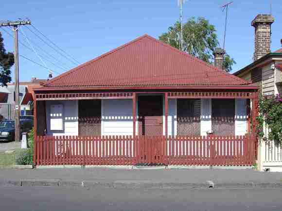
30-32 Campbell Street
Other NameHouse Location30-32 Campbell Street, COLLINGWOOD VIC 3066 - Property No 102640 LevelIncl in HO area not sig |
|


Statement of Significance
Precinct statement of significance Component streets include: Campbell Street, Dight Street, Down Street, Gipps Street, Rupert Street, Vere Street, Statement of Significance What is significant? Clement Hodgkinson's 1853 plan shows that Gipps Street (then Hodgsons Road), Vere Street and Rupert Street had been laid out across the Collingwood Flat (21). The Campbell Street Heritage Overlay Area was shown vacant while a drain carrying water from the swamp just north of Hodgsons Road crossed Rupert Street diagonally on its way to the Blind Creek, drainage being an important and recurring factor in the early development of the Collingwood Flat. In 1857, the Council paved Rupert Street and undertook drainage works. Drains were laid along the length of Gipps Street in 1862. In November 1873, Gemmell, Tuckett and Co. auctioned off most of the land bounded by Dight, Cromwell, Gipps and Vere Streets, forming Dight Street, Campbell and Sturt Streets in the process. Their plan of subdivision included Rokeby Street running north-south between Dight and Campbell Streets. It was never constructed and the proposed route is now occupied by a right of way. The streets were 33 feet wide and each allotment measured 25 feet with an average depth of 62 feet. The land was held by the Metropolitan Permanent Building and Investment Society and, with the modest lot sizes and street widths, the development there was intended for purchase by the working classes, payable 'by monthly instalments'.(22) Most of the land within this Heritage Overlay Area remained vacant by 1880 but by 1881 a total of 23 houses had been built on the east side of Campbell Street and the west side of Rupert Street. By 1886, most of the vacant land had been developed, and a dairy, greengrocer, and wood and coal yard had been established in Campbell Street. A key building in the Collingwood Flat area was the Wesleyan Methodist Church of 1874 and the adjoining school hall, headquarters of the Collingwood Methodist Mission. This complex was appropriately located in one of the municipality's poorest areas. By 1895 the MMBW maps show almost the whole of the locality around the Campbell Street area as densely developed with predominantly small timber buildings. Unlike Fitzroy and Carlton, the Campbell Street area was not affected by the Melbourne Building Act which promoted masonry construction. The most intact streets of small worker's cottages today, Dight and Campbell Streets, are shown on the 1895 plans to contain the most uniform housing, with a great majority having standard designs. As a result of dilapidation, slum clearances and site amalgamation the vast majority of the 19th century residential building stock in this area has been demolished. Consolidation of many small sites has occurred to facilitate the construction of medium to large sized industrial complexes since the post-War period, a trend begun in the late Victorian period by Foy and Gibson. In much of Collingwood this amalgamation has obliterated the original patterns of lot subdivision, leaving only the street alignments and some of the lanes. Main development era Developed as a large working class estate in the late 19th century, but now much reduced in size, the Campbell Street Heritage Overlay Area expresses strongly this aspect of the Victorian-era in Collingwood, with a contribution from individually significant places of all eras. Contributory elements The Campbell Street Heritage Overlay Area contributory elements include (but not exclusively) small attached and detached Victorian-era one-storey houses having typically: . Expressed steeply pitched gabled or hipped roofs; . One storey wall heights and small regular frontage widths; . Weatherboard cladding, with some face brick (bichrome and polychrome) walls; . Corrugated iron roof cladding; . Chimneys of face brickwork with corbelled capping courses; . Post-supported verandah elements facing the street and set on or near the front boundary; . Less than 40% of the street wall face comprised with openings such as windows and doors; and . No or minimal front gardens, originally bordered by typically timber picket front fences of around 1m height integral with the verandah. Contributory elements also include: . Corner shops and residences over, once with large ground level display windows, recessed entries and zero front and side boundary setbacks; . Public infrastructure, expressive of the Victorian era such as stone pitched road paving, kerbs and channels, and asphalt paved footpaths. How is it significant? HO312 Campbell Street Heritage Overlay Area, Collingwood is historically significant to the City of Yarra (National Estate Register [NER] Criteria A4) Why is it significant? The Campbell Street Heritage Overlay Area is significant: . As the largest remnant area of the 19th century working class housing stock which once proliferated in the south of Collingwood, an area noted for its early industrial development, with early street, lane and allotment layouts, some original bluestone kerbs, guttering and lanes; . For the visual containment of the area by the later industrial development surrounding the precinct, emphasized by the contrast in scale between the older residential and more recent industrial buildings; . For the remarkable consistency of Campbell and Rupert Streets, containing substantially intact rows of speculatively developed modest, late 19th century timber workers' housing, characterised by a strong sense of architectural repetition, with rows of similarly detailed housing, uniform cladding materials, setbacks, verandahs, roof forms, chimneys and fenestration patterns; and . As an evocation within the City of exclusion from the Melbourne Building Act of 1849 which controlled building and subdivision standards where, unlike the mainly masonry buildings in Fitzroy and Carlton, most buildings in this Heritage Overlay Area were constructed in timber. References 21flat land in Collingwood generally between the line of Alexandra Avenue on the north, Church Street and the Yarra River on the east, Victoria Street on the south and Wellington Street on the west (see map National Library of Australia. National Library of Australia (ANL)3790435 MAP RM 1643), adjoining the Slope between Smith and Wellington Streets. 22 City of Collingwood. Lithograph No. 00180
Group
Residential buildings (private)
Category
House