| Back to search results » | Back to search page » |
|
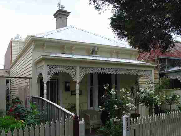
312 Mary Street
Other NameHouse Location312 Mary Street, RICHMOND VIC 3121 - Property No 159015 LevelIncl in HO area contributory |
|


Statement of Significance
Precinct statement of significance Component streets include: Amsterdam Street, Barkly Avenue, Brighton Street, Burgess Street, Coppin Street, Cotter Street, Davis Street, Durham Street, Goodwin Street, James Street, Lesney Street, Mary Street, Rose Street, Yorkshire Street. Statement of Significance What is significant? Survey and development Initially part of the Crown Allotments 7, 8 (sold 1849) and 9 (sold 1880-1882, on the east side of Coppin Street) (14) the Barkly Gardens Heritage Overlay Area was subdivided from 1853, when Brighton Street (then Occupation Road) and Lesney Street were created. By 1854, the present street layout (with the exception of Davis Street and Mary Street) existed. By 1855 the area (mostly north of Rose Street) was being developed for housing and in 1860 the branch railway to Picnic Station (15) at the Yarra River was constructed. Barkly Square Barkly Square was developed on the site of a quarry and first appears on an 1865 survey map. Barkly Square was planted with avenues of trees along a geometrical pattern of gravel paths and with beds featuring specimen trees. At the turn of the century, thousands were attracted to the band recitals held in its rotunda on Sundays. (16) Richmond Primary School Richmond Primary School (Brighton Street School SS1396) was built as a single-storey symmetrical Gothic revival building with polychromatic dressings in 1874 on the block, bounded by Barkly Avenue and Mary, Burgess and Brighton Streets, purchased in 1873. A new school was rebuilt at the Mary Street end of the site in 1976-78, and the original buildings demolished. Main development era The main development period evident in the heritage overlay is that of the Victorian and Edwardian-eras, with a contribution from well preserved interwar buildings and individually significant places of all eras. Contributory elements Contributory elements include mainly (but not exclusively) small Victorian-era and Edwardian-era houses, but with some well preserved residential examples from the immediate post First-War era, having typically: . pitched gabled or hipped roofs; . one storey wall heights; . weatherboard, face pressed brick , bluestone, or stucco wall cladding; . corrugated iron, with some slate roofing; . Chimneys of either stucco finish (with moulded caps) or of matching face brickwork with corbelled capping courses; . Post-supported verandah elements facing the street; . Less than 40% of the street wall face comprised with openings such as windows and doors; and . Front gardens, bordered by low front fences, typically of timber. Contributory elements also include public infrastructure, expressive of the Victorian and Edwardian-eras such as stone pitched road paving, kerbs and channels, and asphalt paved footpaths along with the centre piece of the area, Barkly Square and planting. How is it significant? HO308 Barkly Gardens Heritage Overlay Area, Richmond is aesthetically and historically significant to the City of Yarra (National Estate Register [NER] Criteria E1, A4) Why is it significant? The Barkly Gardens Heritage Overlay Area is significant: . For Richmond's only example of a 19th century residential garden square, a 19th century planning device deriving from London models, and seen also in Curtain Square and the Darling Gardens but otherwise relatively rare in Melbourne, and as reinforced here by Victorian-era houses facing the square along Mary and Coppin Streets; . For the comparatively cohesive image presented by the area of Richmond at the peak of its 19th century development; . For individually significant elements such as the early bluestone and timber Victorian-era houses in the streets to the west of the Barkly Gardens; . For well preserved buildings from the inter-war period that visually complement the core Victorian and Edwardian-era buildings; and . For the high concentration of modest Victorian and Edwardian-era workers' cottages in the low-lying land in the southern part of the Heritage Overlay Area. References 14 Parish Plan. 15 adjoining Richmond Park, now Burnley Park 16 Janet McCalman.Struggletown: Portrait of an Australian Working Class Community 1900-1965. 1984. p 13.
Group
Residential buildings (private)
Category
House