| Back to search results » | Back to search page » |
|
Princes Hill High School, former
Location47 Arnold Street, PRINCES HILL VIC 3054 - Property No 205130 LevelIncluded in Heritage Overlay - Individually Signi |
|
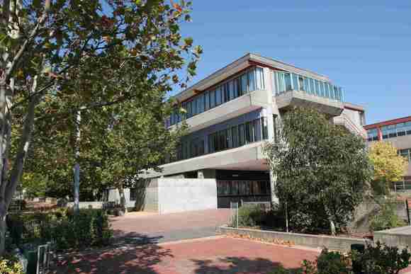

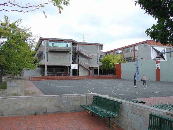
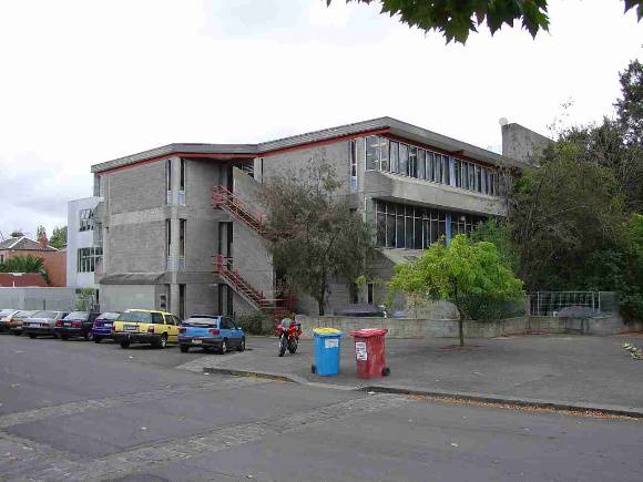

Statement of Significance
Princes Hill High School, 47 Arnold Street, Princes Hill This site is subject to a Statement of Significance for the building, as well as a Statement of Significance for the Precinct in which it is located. Please find below the Statement for the building, followed by the Statement for the Precinct. Statement of Significance for the building What is significant? The Princes Hill High School at 47 Arnold Street, Princes Hill was created in c1973 for the Education Department and has historical associations with the many pupils and staff that have attended the school, as well as the architects Chief Architect, Public Works Dept. in association with Daryl Jackson and Evan Walker. The building won the 1973 RAIA (Vic) Bronze Medal in the General Building Category. New wings have been added since 1983. The place has a good integrity to its creation date. Fabric from the 1970s at the Princes Hill High School, former is locally significant within the City of Yarra, compared to other similar places from a similar era. How is it significant? The Princes Hill High School, former at 47 Arnold Street, Princes Hill is historically and architecturally significant to the locality of Princes Hill and the City of Yarra. Why is it significant? The Princes Hill High School is significant as a major and well-preserved Brutalist style education building design by Jackson and Walker, with all of the attributes of the style being use of off-form concrete and unfinished concrete block work, expression of form such as in stair wells, and exposure of services. It was also the winner of the RAIA Architecture Bronze Medal 1973. Precinct statement of significance Component streets include: Arnold Street, Bougainville Place, Bowen Crescent, Cassar Place, Garton Street, Holtom Street, Keeley Lane, Lang Street, Lygon Street, Macpherson Street, Mcilwraith Street, Park Street, Paterson Street, Pigdon Street, Richardson Street, Solly Avenue, Wilson Street. Statement of Significance What is significant? Subdivision form In 1855 the whole of the area now known as Carlton, including Princes Hill and North Carlton, formed part of Princes Park on the South Ward of the municipality of Melbourne. The Crown land between the cemetery and Pigdon Street was subdivided by the government in 1876-79. The 1879 survey plan shows the new street grid, bounded on the west side by part of the former Princes Park carriage drive (now known as Bowen Crescent). The street layout of Princes Hill was by government survey, as had been the case with North Carlton, and this ensured that planned and regular development occurred from the outset. By 1878 at least twelve dwellings had been erected, and development continued rapidly thereafter. With the exception of a few blocks to the north of the area, few vacant sites remained after the First World War. In Princes Hill, both the streets and generous rear service lanes appeared in the government subdivision, leaving less to the whims of private developers. The use of service lanes was a deliberate Victorian-era design feature to separate the utilitarian functions from formal ones. The subdivision design also enhances the aesthetic beauty of streetscapes, consisting of decorative house facades and gardens that were viewed, as a whole, over low fences. Utilitarian features such as driveways, crossovers, stables and garages were deliberately minimised in the streetscape. Landscape character The original planning of the area, with wide streets and parks along two of the four boundaries, has created a precinct with a sense of spaciousness that contrasts with the closeness of the predominant row houses development and the small front setbacks and gardens.. The overwhelming dominance of one storey housing, interspersed with a maximum of two-storeys, is a key factor which enhances this spacious character. In addition, specific landscape elements such as the wide Pigdon Street boulevard, with its significant avenue of palms and adjoining reserves, and the adjoining Melbourne General Cemetery and Princes Park, all enhance the period landscape character in the area. Commercial and civic development Commercial development in this area was minimal. Apart from the traditional corner shop, most of the shops were developed in a strip along Lygon Street. Public and community buildings are few, but significant places that date from the area's early period of development include the Princes Hill Primary School, in Pigdon Street. At the southern end of the precinct is St Michael's Anglican Church and hall, on the corner of McIlwraith and Macpherson Streets, opposite the Melbourne General Cemetery. Transport The Royal Park to Clifton Hill railway, part of the Inner Circle Railway, opened in May 1888, with North Carlton station located at the corner of Park and Arnold Streets. Tramways, active from the 1880s, facilitated residential development within the area and commercial development on its perimeter. The Inner Circle passenger train link from Clifton Hill to Melbourne (Princes Bridge station) was completed in 1901 and operated until 1948 which explains the popularity of Princes Hill and North Carlton for housing development in the Edwardian and inter-war eras. Good and near original examples of large interwar houses face Lygon Street (see Ridgeway house, 471-475 Lygon St, 1926 and Dr Chambers house and surgery, 609-615 Lygon St, 1926). Main development period The main development period evident in the Princes Hill Heritage Overlay Area is that of the Victorian and Edwardian-eras era with a contribution from some well preserved inter-war buildings and individually significant places ofall eras. Contributory elements Princes Hill Heritage Overlay Area contributory elements include (but not exclusively) generally attached and some detached Victorian-era and Edwardian-era one and two-storey house groups and rows having: . Pitched gabled or hipped roofs, set behind facade parapets in the Victorian-era and exposed in the Edwardian-era and inter-war houses; . Face brick (red, bichrome and polychrome) or stucco walls; . Corrugated iron and slate roof cladding, with some Marseilles pattern unglazed terra-cotta tiles in the Edwardian and inter-war eras; . Chimneys of either stucco finish (with moulded caps) or of matching face brickwork with corbelled capping courses; . Post-supported verandah elements or porches facing the street, with cast-iron (Victorian and Edwardian-eras) or timber detailing (Edwardian-era); . Less than 40% of the street wall face comprised with openings such as windows and doors; . Front gardens, originally bordered by timber or iron picket front fences of around 1m height for the Victorian-era, timber picket fences for the Edwardian-era and inter-war and wire fabric on a timber frame for interwar houses; . Rear and side lanes, with face brick (red) privies set on lanes, (red) and stables with lofts to the larger houses; also . Corner shops and residences, with display windows and zero boundary setbacks. Contributory elements also include typically attached Victorian-era and Edwardian-era mainly two-storey shop and residence rows in the major north south streets, having: . facade parapets, with pitched roofs behind; . face brick (red, dichrome and polychrome) or stucco walls; . corrugated iron and slate roof cladding; . Chimneys of either stucco finish (with moulded caps) or of matching face brickwork with corbelled capping courses and chimney pots; . Post-supported, mainly Corporation Style iron street verandahs as shown on the MMBW Detail Plans (89), . Less than 40% of the street upper wall face taken up with openings such as windows; . No front or side setbacks; also . Timber framed display windows and entry recesses. Contributory elements also include: . Well preserved buildings including one and attic-storey detached houses and two storey flat buildings from the pre Second War era; . Mature street tree plantings (palms, plane and elm trees); . Government designed, regular rectilinear allotment layout, with regular street patterns and widths, wide service lanes, and with Pigdon St as a major planted boulevard; . Views to adjoining parklands and the Melbourne General Cemetery; and . Public infrastructure, expressive of the Victorian and Edwardian-eras such as bluestone pitched lane and road paving, crossings, stone kerbs, and channels, iron bollards and gas lamp bases, and asphalt paved footpaths. How is it significant? HO329 Princes Hill Heritage Overlay Area is aesthetically and historically significant to the City of Yarra (National Estate Register [NER] Criteria E1, A4) Why is it significant? The Princes Hill Heritage Overlay Area is significant: . As a highly intact example of a mid to late 19th and early 20th century, middle-class inner Melbourne residential area, with associated perimeter commercial strip development, wide streets, regular allotment sizes and street layout - all providing a strong and well defined residential character that demonstrates the functions of daily life as they were in that era;, . As a fine illustration of Victorian and Edwardian-era domestic architecture with many highly decorated one-storey attached houses, interspersed with a some of two storeys and some detached villas, most with verandahs and all with steeply pitched hipped and/or gableroofs and chimneys and some ornamental parapets, all creating a picturesque skyline which contributes to the aesthetic beauty of the streetscapes in an area of traditional high density development; . For the well-preserved utilitarian features of the area's residential development, with many stable loft buildings that face spacious rear lanes and the deliberately siting of driveways, crossovers and stables/garages away from the street frontages, in rear lanes, as a key aspect of Victorian-era life; . For the large number of contributory and individually significant buildings, including the Edwardian terraces, and freestanding villas from the Victorian, Edwardian and inter-war eras that are outstanding for their extent, exuberance of the architectural detail, richness and intactness - reflecting the affluence of many of the inhabitants of this area, particularly in the late 19th century; . For the individually significant buildings from all eras, as well as visually related and well preserved examples from key periods in the City's history, specifically the individually significant post Edwardian-era buildings, including the 1970s Brutalist Princes Hill Secondary College(former High School), detached inter-war villas and flat blocks, with good detached house examples set along the wider streets such as Lygon and Pigdon Streets; . For the early engineering and infrastructure such as the street, lane and allotment layouts, original or early materials for bluestone kerbs, guttering, lanes, crossovers, asphalt footpaths and roads, and the presence of some mature exotic street trees, provide an important setting for this collection of significant buildings; . For its distinctive urban landscape character, with the Melbourne General Cemetery, public reserves and Princes Park along three boundaries plus the school reserve along the north boundary, combining to create a spaciousness setting for the dense urban character of the area's dominant row house development; . For the key views to significant urban landmarks and landscapes, including St Michael's Church and Hall, the Melbourne General Cemetery and Princes Park (as visual connections to the earlier history of the area), the Pigdon Street avenue of palms and the Gallagher Reserve (Inner Circle Railway), with physical links to the area's origins retained in the form of the former Princes Park carriage drive (now Bowen Crescent) and views to the park itself along the east-west streets of the area. References 89 See MMBW Detail Plan 1196 of 1899
Group
Education
Category
School - State (public)