| Back to search results » | Back to search page » |
|
High Street - Northcote Historic Area
Other NameEpping Road (1842-1853), Plenty Road And Upper Plenty Road (1860s). LocationHigh Steet,, NORTHCOTE VIC 3070 - Property No B7210
File NumberB7210LevelRegional |
|


Statement of Significance
High Street at Northcote runs across the river flats north from Merri Creek and climbs the steep escarpment near Clarke Street on to and across Rucker's Hill. The first Government land sales in this area were in 1839, but the land south of Westgarth Street was retained in Crown ownership as part of Melbourne's township reserve. In 1842 High Street was proclaimed as a narrow government road running north from this crown reserve through the privately owned allotments on Rucker's Hill towards the Plenty River district. In 1852 Robert Hoddle laid out the government township of Northcote on the Merri Creek flats, and laid out High Street through the new township as a three chain wide boulevard. By the 1860s however it was clear that the focus of settlement, rather than being on the flats, would be on the plateau at Upper Northcote. Here there were some small farms, cottages and small-scale industries, as well as substantial houses built to take advantage of the extensive views, and businesses were established to service these. Westgarth Street marks the separation between the gracious scale, elm avenues and residential character of Hoddle's 1852 boulevard, and the later speculative commercial development to the north.
The growth of Lower Northcote and Westgarth (at the base of the escarpment) on the flats remained slow during the nineteenth century. The 1860 bluestone Church of All Saints remains the most prominent building on the boulevard, which is now mainly occupied by detached late nineteenth and early twentieth century houses. Plantings of elms survive from 1885, as well as the 1905-7median gardens and rockeries, and two obsolete guns that had protected the South Channel in Port Phillip Bay since 1887 which were placed there in 1913.
A new stone bridge with two huge brick arches over the Merri Creek was completed in 1875, and is one of Melbourne finest riverine bridges. However Upper Northcote remained relatively isolated from the city, and its development slowed in the 1870s. The only access was via the steep and dangerous road up Rucker's Hill; the cable tram from the city terminated at Merri Creek, and even the horse bus service to Northcote had been cancelled at this time. Despite this the settlement grew rapidly in the 1880s, along with the rest of suburban Melbourne. The High Street shopping strip frontages began to be subdivided and redeveloped, and substantial commercial and civic buildings began to be built.
In 1888-1890 the cable tram route was continued from Clifton Hill to Upper Northcote. This required the building of an enormous ramp up the escarpment of Rucker's Hill, on an embankment supported by a bluestone wall, as well as the widening of the Merri Creek bridge. The embankment is topped with regularly spaced Peppercorn trees, and a fine granite drinking fountain is located at its base on the east side. A row of mature Elm trees planted at the base of the west abutment provides a tree canopy visible above the tramway ramp and complements the Peppercorns. The tramway ramp affords dramatic vistas towards the city, and to the hilltop church spires on each side of High Street.
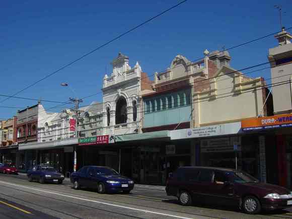
The cable tram was a further stimulus to development of Upper Northcote. High Street developed the characteristic long shopping strip form associated with the cable tram routes. Most of the existing buildings in this part of High Street, including shops, banks, churches and civic buildings, date from between the 1880s and the collapse of the boom in 1891, and form a highly cohesive group. After the 1890s depression, and again after World War I, development picked up. The most significant building on the strip is the Northcote Theatre (1912), which is Victoria's earliest surviving purpose-built cinema. This section has always been the commercial, banking, and entertainment centre of Northcote. It retains its character as a Boom-era cable-tram route shopping strip, with some additional commercial development dating to 1940. The retail strip continued to develop further north of Separation Street following WWI, reaching the end of the cable tram line at the Plenty Road (Dundas Street) intersection by about 1940, creating a particularly long retail strip. This section is mainly single storey, dotted with interwar hotels, banks, and former cinemas and some later twentieth century large-area shops and car-yards.
The 1.75 km thoroughfare of High Street, Northcote, between Merri Creek and Separation Street, includes the Merri Creek bridge, the 1852 Hoddle residential boulevard on the wide Merri Creek floodplain, the small and contained nineteenth and early twentieth century Westgarth shopping centre south of the escarpment, the 1888-90 cable tram ramp up Rucker's Hill escarpment, Northcote's religious and public buildings precinct on the city edge of the Rucker's Hill, and the nineteenth and early twentieth century commercial and retail development along the ridgeline of the Rucker's Hill plateau. The view of the city from the south edge of Rucker's Hill is one of Melbourne's major urban vistas.
How is it significant? The High Street, Northcote thoroughfare, including the Merri Creek bridge, is significant for aesthetic/architectural, historic, social, scientific/ technical reasons at a Regional level.
Why is it significant? High Street Northcote is historically significant as one of Melbourne's major nineteenth century thoroughfares, and for demonstrating important aspects of the planning of nineteenth century Melbourne. The change in the nature of High Street which occurs at Westgarth Street is historically significant for demonstrating the contrast between the government-planned land use and subdivision to the south, and the private development to the north. The residential character of the area close to Merri Creek is also significant, typifying the early development of Melbourne's sixty metre boulevards as gracious housing precincts. The long shopping strip along High Street is historically significant as a reflection of the importance of the cable tram routes in shaping Melbourne's commercial development. The section between Rucker's Hill and Separation Street is part of a remarkably long retail strip - at about 3 kms, it is the second longest continuous shopping strip in Melbourne. The 1885 elm plantings along the boulevard, and the medians and rockeries of 1904, embellished with guns from Port Phillip Bay, are historically and socially significant as markers of the entry to the Northcote municipal district for the last hundred years.
The section of High Street immediately north of Westgarth Street is architecturally significant for its consistent nineteenth and early twentieth century architectural scale and character, which is punctuated by two important interwar buildings, the 1921 Westgarth Theatre and former 1925 State Bank opposite.
The part of High Street at the southern end of the Rucker's Hill plateau is a prestigious elevated locale with extraordinary views over Melbourne. It is historically and socially significant as the seat of local government, the centre of police and community services, cultural activity and religious worship. It is architecturally and aesthetically significant as a collection of sophisticated buildings demonstrating various styles by notable architects. These include the richly decorated facades of George R. Johnson's Town Hall and the Carnegie Library by local architect Edward Twentyman Jnr., and the Victorian Public Works Department avant-garde Elizabethan-style Police Station. These are enhanced by the surrounding skyline of prominent church spires including that of the Gothic revival Catholic Church, French Romanesque Presbyterian Church and the severe, almost brutal red brick Church of the Epiphany designed by Louis Williams, situated opposite on the highest point of Rucker's Hill.
The section of High Street on Rucker's Hill south of Separation Street is historically and socially significant as the commercial, banking, and entertainment centre of Northcote since its commencement as a small village centre during the mid 1850s. It retains its character as a Boom-era cable-tram route shopping strip with significant additional commercial development built up until 1940. It contains the former Northcote Theatre (1912), which is Victoria's oldest surviving purpose-built cinema, and some early buildings, including the bluestone Wesleyan schoolhouse (1854, rear elevation only intact), the Peacock Hotel (1854, altered) and the Wesleyan Church (1869). This section is architecturally and aesthetically significant for its dense and consistent streetscape scale, its classical commercial shop facades and banks, and the variety of buildings of various periods and styles from the 1860s to about 1940, including such moderne buildings as the late 1930s former Bank of New South Wales, 326-30 High Street. The concentration of important buildings on street corners is noteworthy, especially at Westbourne Grove, Bastings and Lawry Streets. Side street skyline vistas are important to the sense of High Streets elevated location on the plateau.
There are also two individual elements in this precinct of scientific/technological significance. The 1875 Malmsbury stone bridge, with two huge brick arches over the Merri Creek, is one of Melbourne finest riverine bridges. The 1888-90 tramway ramp built on the steep escarpment of Rucker's Hill is a very rare example of its type. It is technologically significant as an impressive work of nineteenth century engineering. It is also historically significant for demonstrating the great impact of suburban railway and cable tramway services on the expansion of Melbourne during the late nineteenth and early twentieth centuries, which enabled Northcote's rapid Boom era and pre-World War I growth. It is also historically significant as a remaining feature of what was the last cable tram route to continue in service in Melbourne.
Classified: 19/06/2004
Group
Urban Area
Category
Streetscape