| Back to search results » | Back to search page » |
|
Surrey Hills North Residential HO535
LocationWest Road, Chatham Road, Croydon Road, Empress Road, Guildford Road, Junction Road, Kngston Road, Mont Albert Road, Sir Garnet Road, Sunbury Crescent SURREY HILLS, BOROONDARA CITY LevelIncluded in Heritage Overlay |
|


Statement of Significance
What is Significant
Why is it Significant
The Surrey Hills North Residential Precinct is of local historical
significance, as a long-standing residential area in the northern part
of Surrey Hills, which demonstrates aspects of the growth and
consolidation of the suburb from the latter decades of the nineteenth
century through to the later interwar period. John H Knipe, an early
landowner in the precinct, was reputedly the first to use the name
'Surrey Hills' when he subdivided his landholding in 1878. Mont Albert
Road, the principal road in the precinct, is one of Boroondara's
oldest roads. More intensive development in the precinct commenced in
the 1880s after the extension of the railway line to Lilydale, the
construction of the station in 1882, and the promotion of the area as
a desirable residential location. The economic Depression of the 1890s
stymied development, until building activity resumed in the first
decades of the twentieth century. The extension of the tram line along
Whitehorse Road to Union Road in September 1916 stimulated development
in the precinct, as was the later opening of the Chatham railway
station in 1927. By 1920, much of the remaining vacant land in the
precinct area had been built out. The precinct also accommodated new
homes for returning World War One soldiers, including in bungalows
designed, promoted and financed by the State Savings Bank of Victoria.
After the Second World War, as with other parts of Boroondara, the
advent of the motor car confirmed Surrey Hills as a dormitory suburb
for Melbourne workers. Surrey Hills North Residential Precinct is also
of local aesthetic/architectural significance, comprising housing with
a comparatively high level of intactness from two main periods of
development, being the late Federation period of 1910-1915, and the
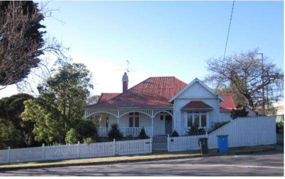
interwar period of the 1920s and 1930s to early 1940s. The Federation
houses derive from a time in Australian architecture when a
distinctive national style was developing, influenced by the
international Arts and Crafts movement, Art Nouveau, and elements of
the Queen Anne mode. Valued characteristics of Federation houses in
the precinct include simple L-shaped plans with a single projecting
gable, often half-timbered; hipped roofs played off against the
projecting gables; diagonal components such as angled corners or
curved bays, sometimes coupled to an angled gablet or corner tower;
and hinged casement windows often grouped in threes and fours. The
1920s houses in the precinct are generally bungalow variants, in a
style influenced by contemporary American bungalows, including those
of California as well as 'Craftsman' bungalows. Valued characteristics
of these precinct dwellings include conspicuous transverse roof forms
with gable ends (typical of Melbourne bungalows, and of the Craftsman
style), or two superimposed gables; forward-sloping roofs which
emphasise the horizontal massing, and often integrate with verandahs;
and verandahs enclosed by medium-height walls usually in the same
materials as the house walls, with paired square-plan timber posts or
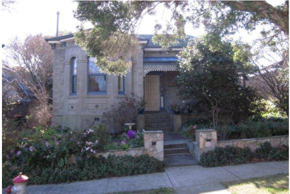
occasionally brick piers clad in stucco. Distinguishing
characteristics of the 1930s -early 1940s houses include porch areas
(rather than verandahs); hipped roofs with lower pitches; and more
simply detailed chimneys. There are also more references to 'past'
styles, such as Tudor, often conveyed in clinker or tapestry brick.
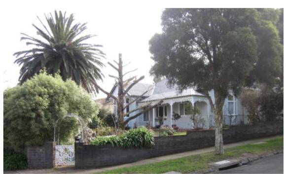
The Victorian houses, which are mostly in the Victorian Italianate
style, display bracketed and hipped roofing; some with block front
detailing to resemble stone; broad double-hung timber-framed sash
windows; and chimneys which are corniced and either stuccoed or in
exposed red face brick. Established gardens also contribute to the
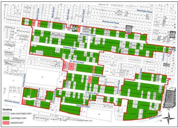
aesthetic values of the precinct, as do street or median plantings. For a full list of the individual gradings within the precinct,
please refer to the attached PDF citation, or the child records.
The Surrey Hills North Residential Precinct is a large precinct
area located in Surrey Hills, and part of Canterbury, and bounded (in
general terms) by the railway embankment and Sunbury Crescent to the
south; Mont Albert Road to the north; Chatham Road to the west; and
(approximately) the east boundaries of properties running parallel
with Union Road in the east. Streets in the precinct predominantly run
from east to west, with generally lesser (shorter) streets, other than
Chatham Road, running north-south. Mont Albert Road is the principal
road within the precinct, and defines the northern precinct boundary.
There are two main periods of residential development, being late
Federation concentrated in the period 1910-1915; and the interwar
period of the 1920s, 1930s, through to the early 1940s. Generally,
houses are constructed of timber, timber and rough-cast stucco, and
brick or brick and render. Timber houses are in the majority, which is
typical of Surrey Hills. Dwellings range from large brick houses on
generous allotments to more modest timber bungalows. There are also
clusters of earlier housing comprising late Victorian residences; and
a small pocket of attached commercial buildings from c.1910 on the
north side of Mont Albert Road, adjoining Wells Street. Established
gardens are another feature of the area; street, or median, plantings
are also characteristic, including in Croydon, Guildford, Empress, Sir
Garnet, Kingston and Mont Albert roads.
The precinct comprises a
high number of properties which have are graded 'contributory', with
relatively few graded 'significant'.
How is it Significant Surrey
Hills North Residential Precinct is of historical and
aesthetic/architectural significance to the City of Boroondara.
Group
Residential buildings (private)
Category
House