GREAT OCEAN ROAD
GREAT OCEAN ROAD BETWEEN TORQUAY AND ALLANSFORD, SURF COAST SHIRE, COLAC OTWAY SHIRE, CORANGAMITE SHIRE, MOYNE SHIRE
-
Add to tour
You must log in to do that.
-
Share
-
Shortlist place
You must log in to do that.
- Download report




Statement of Significance
-
-
GREAT OCEAN ROAD - History
CONTEXTUAL HISTORY
War Memorials
War related heritage plays an important role in the lives of Victorians and most towns have some form of war memorial. Australian war memorials in towns and cities take the form of public sculptures, shrines, memorial walls and gates, honour rolls, avenues of honour, gardens, buildings and even swimming pools. The Australian War Memorial notes they may be in the form of the "ubiquitous 'small town memorial' to the large-scale monuments of national significance".
The Great War of 1914-1918 fostered an enormous community need to establish lasting memorials as a statement of bereavement, pride and thanksgiving to all those who served their countries, and Australia has more war memorials than any other country. The idea of planting avenues as memorials appears to have originated in Britain in 1918 and became popular in Australia and other Commonwealth nations. The practice of establishing memorial avenues was most apparent in Canada, Australia and New Zealand, where monuments of stone and living memorials such as gardens and avenues were patriotically supported by most citizens. Other memorial avenues have been created following World War II and the Vietnam War.
Victoria retains about 250 Avenues of Honour and six of these are included in the Victorian Heritage Register. The largest is the Ballarat Avenue of Honour, a memorial avenue of exotic trees that extends for 22 kilometres from the Arch of Victory at Ballarat, toward Learmonth.
Repatriation Work
Over 400,000 men enlisted for the First World War, and the return of those deployed abroad posed the problem of their repatriation and the difficulty of re-skilling and employing them. The new Federal Government acknowledged that it had a responsibility to assist returned soldiers to resume their lives upon discharge. In combination with the war pensions and soldier settlers schemes, the repatriation works program was part of Australia's social policy of assistance for returned servicemen and women. The Repatriation Fund was established with grants from the Federal and state governments, as well as public donations. The Repatriation Department was responsible for apportioning the funds to veterans and projects and the State War Councils were tasked with developing the lists of public and municipal works. The Repatriation Department kept the central list of public works that could employ returned soldiers.
Landscape protection planning
Prior to Federation, the colonial governors were directed to reserve coastal lands for public purposes and at Federation the former colonies retained many of their original powers, including overall management of the coastal zone. From as early as the 1930s many seaside locations were protected to enable increasing numbers of tourists and residents access for recreational and leisure activities. This has resulted in diverse administrative systems for coastal management.
Scenic tourism routes
Scenic tourism routes exist throughout Australia, and coastal routes in Australia and abroad are particularly popular tourist journeys. Initially scenic tourism routes were traversed by rail. With the increasing availability and popularity of cars, in the early twentieth century the Victorian Government began works to assist the development of a number of tourist 'resort' areas through the construction of scenic roads and railways on the outskirts of Melbourne and in regional Victoria.
Significant People
McCormack, William Thomas Bartholomew (1879-1938)
Excerpt taken directly from the Australian Dictionary of Biography (online: http://adb.anu.edu.au/biography/mccormack-william-thomas-bartholomew-7321)
William Thomas Bartholomew McCormack (1879-1938), civil engineer and public servant, was born on 1 January 1879 at Heathcote, Victoria, son of Thomas McCormack, Irish-born publican and his wife Emily, nee Ewen, of Sydney. Educated at the local state school and privately, he worked as a clerk in the shire office at Seymour before being appointed in 1902 secretary and shire engineer at Mirboo, Gippsland. On 27 September 1904 at Mirboo Catholic Church, he married Margaret Muirhead. Certificated as municipal surveyor, hydraulic engineer and municipal clerk (Victoria) and engineer (New South Wales), he worked as shire engineer at Lockhart, New South Wales, and Korumburra, Victoria, before being appointed in 1909 to the Public Works Department as assistant engineer, engaged in constructing roads and levees and reclaiming swamps. He was an honorary lecturer in engineering at the University of Melbourne in 1913-15, a foundation member of the Institution of Engineers, Australia, and a member of the Institution of Civil Engineers, London.
In March 1913 McCormack was appointed one of the three foundation members of the Country Roads Board of Victoria. In 1913-15 they travelled widely, frequently on horseback, to lay the foundation of the State's road network. McCormack's knowledge of local government, his diplomatic skills and quiet, equable personality made him a successful ambassador for the board in its negotiations with sometimes fractious shire councils.
A lieutenant in the Australian Intelligence Corps in 1911-14, McCormack enlisted in the Australian Imperial Force in January 1916 and in June embarked as major commanding the 10th Field Company, Engineers. In 1917 he acted as commanding royal engineer, 3rd Division, under his mentor Major General (Sir) John Monash. Following the battle of Messines he was mentioned in dispatches and in August 1918 was awarded the French Croix de Guerre. After the war he briefly studied British road construction, town planning, sewerage and water-supply.
Returning to Australia in April 1919 McCormack resumed his work with the Country Roads Board, taking charge of the construction, initially by returned soldiers, of the Great Ocean Road which reached Eastern View in 1922 and, eventually, Apollo Bay in 1932. Acting chairman of the board during William Calder's visit to Europe and the United States of America in 1924, he was appointed chairman upon Calder's death in March 1928. During his decade in office about 11,000 miles (17,703 km) of roadway were under his jurisdiction and in that time much of its macadam surface, suitable for horse-drawn vehicles, was replaced with more durable bitumen and gravel. He also established the board's research laboratory. In 1937 McCormack visited North America to study advances in road-building and published a report on his return.
Memorials to him include an archway at Eastern View, opened by General Sir Harry Chauvel in 1939.
Calder, William (1860-1928)
Excerpt taken directly from the Australian Dictionary of Biography (online: http://adb.anu.edu.au/biography/calder-william-5466)
William Calder (1860-1928), engineer, was born on 31 July 1860 at his father's sheep-farm at Lovell's Flat, Milton near Dunedin, New Zealand, only son of Arthur Calder and his wife Margaret Milne, nee Strachan. Calder was educated at the local school at Milton and the Otago Boys' High School in Dunedin in 1876-77. From 1881 he attended engineering lectures at Otago University before entering the New Zealand Government Survey Department as a cadet in October 1883; after five years practical training he passed the authorized surveyors' examination with credit in July 1888. Later that year Calder came to Victoria and worked in private engineering and surveying firms. He studies at night to gain certificates as municipal engineer (1890) and water supply engineer (1892).
By 1912 the appalling condition of Victoria's rural roads was a major concern to both farmers and motorists. That year a Country Roads Board was set up and Calder was appointed chairman, with W. `T. B. McCormack and F. W. Fricke as the other members. In its first two years, the board travelled ceaselessly, inspecting a road system neglected by indigent municipalities since the building of the railways. A meticulous note-taker and enthusiastic photographer, Calder recorded the board's progress; his notes were transcribed and used as a basic reference for many years. Maps were published in 1914 and 1915 showing the roads selected for improvement. The board was endlessly tactful in receiving interest groups pressing for various improvements, while insisting on high standards of construction and financial control.
After 1918 there were shortages of money and manpower for road-building. Calder campaigned publicly and privately for more funds, especially for arterial roads, and invariably attained rapport with a succession of ministers. In 1924 he toured Europe and North America; his report, published that year, is widely regarded as a classic of road-construction practice and road-administration. In it he evaluated the contemporary controversy over the use of cement concrete (the American model) and bituminous pavement (the British); he favoured the latter for Australian conditions. Other recommendations included experiments with new materials and a fuel tax to replace the vehicle tax. Maintenance was to be given high priority, and he also stressed the importance of regulation of motor transport to preserve road surfaces and to raise revenue.
Many of Calder's recommendations were included in the important Highways and Vehicles Act of 1924, which provided for the declaration of State highways, two-thirds financed by the State government through the C.R.B. This network of highways is perhaps Calder's main achievement: the road to Bendigo and Mildura was named after him. The board's organization was copied in other States, New Zealand and Fiji. He long advocated Federal assistance in highway construction, and attended the first meeting of the Federal Aid Roads Board set up under the Act of 1926.
Memorials to him include an avenue of trees on the road to Geelong beginning one mile past Werribee, cairns at Warragul and elsewhere in Gippsland, and a bridge at Moe. A Tom Roberts portrait hangs in the CRB (Vicroads) board room, Kew.
Hitchcock, Howard (1866-1932)
Excerpt taken directly from the Australian Dictionary of Biography (online: http://adb.anu.edu.au/biography/hitchcock-howard-6685)
Howard Hitchcock (1866-1932), businessman and civic leader, was born on 31 March 1866 at Geelong, Victoria, son of George Mitchelmore Hitchcock and his wife Annie, nee Lowe. He was educated at Flinders State School and private schools before beginning at 18 as an assistant in the family firm of Bright & Hitchcocks, drapers. Five years later he became a junior partner; on his father's death in 1912 he took over as managing director. In 1926 he sold the business to five of his employees.
Hitchcock was prominent in the Yarra Street Wesleyan Church, serving for over twenty-five years as organist and over ten years as secretary and superintendent. He was also a member of the church tennis and cricket teams. These activities formed his main interests until 1915 when, after successfully campaigning to prevent the Geelong City Council from moving its headquarters to the recently vacated Geelong Church of England Grammar School buildings, he was prevailed upon to stand for council. Elected as representative for Bellarine Ward, within two years he was chosen as mayor and served a record consecutive five years in that office in 1917-22. He became an alderman in 1920, and was appointed O.B.E. that year and C.M.G. two years later.
During his mayoralty Hitchcock accepted all invitations, attending three or four functions in an evening, and travelled 80,000 miles (128,747 km) in his own car. His slogan was 'civic improvement and beautification' which he put into practice in development schemes for Johnstone's Park and the Eastern Beach. He firmly believed that those who had made their fortune in the town should be prepared to plough it back into its development, and he established a Junior Civic Association to instil his 'new civic ideal' into the minds of the young. He never ceased to push the merits of Geelong, extending to visitors lavish, though teetotal, hospitality out of his own pocket.
Hitchcock was active in fund-raising activities during and just after the war. He helped to obtain £1.5 million for war loans and £132,000 for various war and peace funds, including the Kitchener Memorial Hospital. His own donations often reached four figures. While mayor Hitchcock was also active president or chairman for thirty-one public bodies, vice-president of five, trustee of ten, secretary of four, treasurer of four and committee-member of seven.
Hitchcock's interests turned outside Geelong when he espoused William Calder's proposal for the establishment of the Great Ocean Road as a memorial to the soldiers of the Western District. He became president of the Great Ocean Road Trust in 1918; he gave nearly £3000 to its appeal and it was his enthusiasm and energy as much as anything that kept the project afloat. He died before he was able to open the completed road in 1932; in tribute, his car was driven behind the governor's in the procession along the road on opening day.
Great Ocean Road History
The 1850s timber settlements around Louttit Bay and Apollo Bay initially relied on shipping for the transport of goods in and out of the settlements due to the continuing difficulty accessing them by road.
In 1908 a Lorne resident, E.H. Lascelles, founder of a Geelong wool firm, suggested opening of a coastal road to make the most of the seascapes and ocean views but it was eight years before discussions commenced between the State War Council and the CRB in 1916, who were required to to find road projects which could provide employment for returned servicemen. One of the road projects suggested by William Calder, Chairman of the board, was the South Coast Road which he described as being 'somewhat along the lines of the Coast Road constructed by the Highway Commission of California, which has proved such an enormous asset to the State of California by the attraction of tourists from all parts of America'. Calder further noted that 'along the whole route the scenery is magnificent and extremely varied and that it would be a fine asset to this State by attracting tourists from all parts of Australia'.
After these deliberations, the Great Ocean Road Scheme was proposed in 1917 and formally launched at Colac on 22 March 1918. It was anticipated that the road would cost ₤150,000.
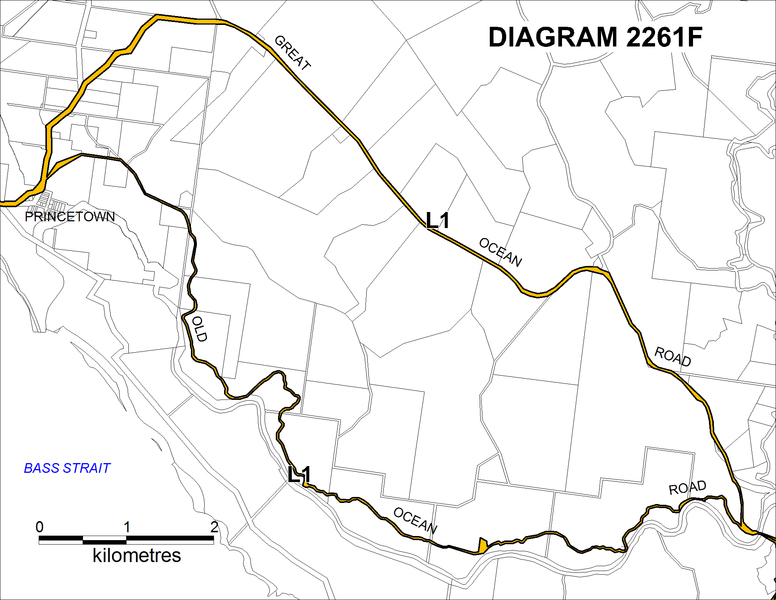
The road was to start at Barwon Heads following the coast through Torquay to Apollo Bay, then inland through the Otway Ranges to Princetown, then again along the coast to Peterborough. At Nirranda it would join an existing road to Warrnambool. Initial surveys for the route of the road took place in 1918, and construction officially commenced in 1919.
The GOR was the combined vision of Calder, Hitchcock and McCormack, and Hitchcock was made the inaugural President of the Great Ocean Road Trust in 1918.
The construction of the Great Ocean Road was one of the largest of repatriation works programs. In 1934 when the road required metalling and widening, 400 returned servicemen participated in the work, completing the road surfacing from Geelong to Warrnambool.
Although there were some existing sections of road linking towns on the west coast, the majority of the GOR was constructed between 1919 and 1932. The new sections were Anglesea to Big Hill; Lorne to Apollo Bay; Apollo Bay to Glen Aire; Lower Gellibrand to Princetown; and Port Campbell to Nirranda. More than 3,000 returned servicemen laboured on surveying the track and blasting and carting rock. They used picks and shovels to chisel the steep hillsides and level the roadway, and stayed in numerous camps along the road from Eastern View to Hordern Vale, always near a source of fresh water.
Work Camps
Camps were established at Grassy Creek, Big Hill and Wye River early in the works, and some were still occupied by 1933. Some camps accommodated around 100 men, while others, such as one by the St George River, had only 20 men in 1933.
Information regarding the length of occupation of each of the camps along the Great Ocean Road has not been located, but some may have been occupied from 1920 until at least 1933.
Wooden mess huts, galvanised iron drying rooms and kitchens were established at the sites. The camps were serviced by vegetable plots and cooks and there are records of pianos being supplied for entertainment. Food was provided at cost, and some workers recalled that fish and rabbits supplemented the rations.
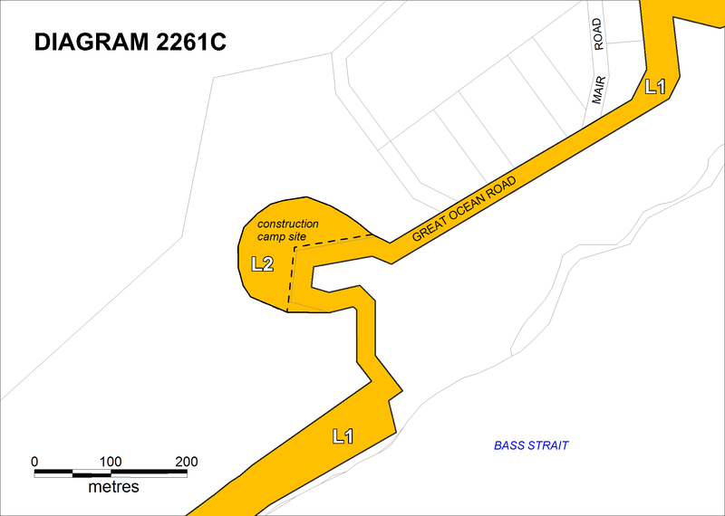
Camps were located at Eastern View, Stony Creek (Lorne), Grassy Creek, Big Hill Creek, Sheoak River, St Georges River, Cumberland River, Cape Patton (Ramsden Farm), Wye River, Kennett River, Skenes Creek, Glen Aire, Lavers Hill and Hordern Vale. Approximately half of the camps were related directly to works run by the CRB, and the others to works run by the Great Ocean Road Trust, depending on the section of road the workers were constructing. While some of the camps may be located in areas that have been impacted by later developments, such as the camp site at Cumberland River, others are likely to be relatively undisturbed due to their remote locations and dense vegetation.
REFERENCES:
Alsop, P.F.B. (1982). A History of the Great Ocean Road. Geelong Historical Society. Geelong, Victoria.
Alsop, P.F.B. (1965). A Brief Account of the Genesis and History of the Memorial 'Archway' at Eastern View on the Great Ocean Road. Geelong.
Cecil, K.L. & Carr, R.V. (1988). The roads to Lorne: the story of communication between Geelong and Lorne, including that via the ANZACS' Highway. Anglesea & District Historical Society, Anglesea, Victoria.
Country Victoria Tourism Council and Tourism Victoria (2000). Great Ocean Road Tourism Development Plan. Country Victoria Tourism Council, Melbourne.
Cousland, C. (2007). Travelling the Great Ocean Road, a journey through time and place. Petticoat Publishing.
Crocker, R & Davies, B. (2005). Identifying Inspirational Landscapes - Stage 2. Volumes 1, 2 & 3. Unpublished report for the Department of Environment and Heritage. April 2005.
Department of Sustainability and Environment (2004). Great Ocean Road Region. Towards a vision for the future. A land use and transport strategy. DSE, Melbourne.
Fagetter, R. (2000). The Great Ocean Road from Where to Where. Unpublished paper.
Gourlay, M. (2000). History of coastal engineering in Australia. Keynote Address to 27th International Conference on Coastal Engineering, Darling Harbour, Sydney 17 - 21 July 2000.
Hepper, J. (1984). Future Directions for Landscape Assessment Planning in Tasmania: a report prepared for the Tasmanian Conservation Trust Inc with funds from the National Estate Office of Tasmania. Unpublished report.
Hyett, R. (1995). The Great Ocean Road: A Traveller's Guide. Great Ocean Publications, Port Campbell, Victoria.
Inglis, K S. (2008). Sacred Places: War Memorials in the Australian landscape. Melbourne University Press, Melbourne.
Land Conservation Council (1997). Historic Places Special Investigation South West Victoria. LCC, Melbourne.
Lloyd, C. & J. Rees. 1994. The Last Shilling. A history of repatriation in Australia. Melbourne University Press, Melbourne.
Mary Sheehan & Associates (2003). Colac Otway Heritage Study. Volume 1.
Mosley, G. (1997). Where the forest meets the sea a conservation strategy for the Great Ocean Road Region. For Australian Conservation Foundation, Geelong Environment Council and Great Ocean Road Committee. Fitzroy, Victoria.
National Trust of Australia (NSW) Conservation and Landscape Committee (1972). Hunter 2000: Conservation of lands and buildings of natural, historical, scenic or recreational value in the Hunter Region. National Trust of Australia (NSW), Sydney.
Parks Victoria (1998). Port Campbell National Park and Bay of Islands Coastal Park Management Plan. Parks Victoria, Kew, Victoria.
Parks Victoria and the Department of Sustainability and the Environment (2008). Caring for Country, the Otways and you. Great Otway National Park and Otway Forest Park Draft Management Plan. Parks Victoria and Department of Sustainability and Environment, Melbourne.
Planisphere (2003). The Great Ocean Road Region Landscape Assessment Study. Municipal Toolkits for Corangamite, Colac Otway and Surf Coast Shires. For Department of Sustainability and Environment, Melbourne.
Rowe, D. (2002). The Pleasure Grounds of the Barwon Coast: A History. Barwon Coast Committee of Management Inc. Barwon Heads, Vic.
Surf Coast Shire (2004). Surf Coast Planning Scheme: Coastal Development Policy. Local Planning Policies Clause 22.01. Retrieved 11 November 2009 from http://www.surfcoast.vic.gov.au/Planning/Documents/Coastal%20Development%20Policy.pdf.
Victorian Coastal Council (1998). Landscape Setting Types for the Victorian Coast - May 1998. Report by Tract Consultants Pty Ltd and Chris Dance Land Design Pty Ltd for the VCC, Melbourne.
Victorian Coastal Council (2002). Victorian Coastal Strategy. VCC, Melbourne.
Western Coastal Board (2002), South West Victoria Regional Coastal Action Plan. Western Coastal Board, Victoria.
GREAT OCEAN ROAD - Plaque Citation
This 242 km road is an iconic tourist route renowned for its scenery. It was constructed by more than 3000 returned servicemen between 1919 and 1932 as a war memorial, a repatriation project and to attract tourists to the area.
GREAT OCEAN ROAD - Assessment Against Criteria
Criterion
Criterion (a) Importance to the course, or pattern, of Victoria's cultural history
The Great Ocean Road is historically significant as a war memorial constructed between 1919 and 1932 by 3000 returned servicemen through the repatriation employment program to honour their fellow diggers from the First World War. Links to the First World War are evident in some geographical names along the road, such as Sausage Gully and Shrapnel Gully, two battlefields at Anzac Cove, Gallipoli. It is important for the numerous memorial plaques and features located on the route, including the Memorial Arch at Eastern View, and the plaques at Eastern View and Mount Defiance. The road is a physical reminder of post-war conditions for ex-servicemen in Victoria following the First World War and of the construction workers who worked on the road. The associated construction camps are historically important as demonstrating the working conditions under which the road was built.
Criterion b Rarity
The Great Ocean Road is historically significant as a World War 1 war memorial and is the only war memorial road in Victoria, though many local avenues of honour were planted with memorial trees for individual servicemen.
Criterion (c) Potential to yield information that will contribute to an understanding of
Victoria's cultural history.
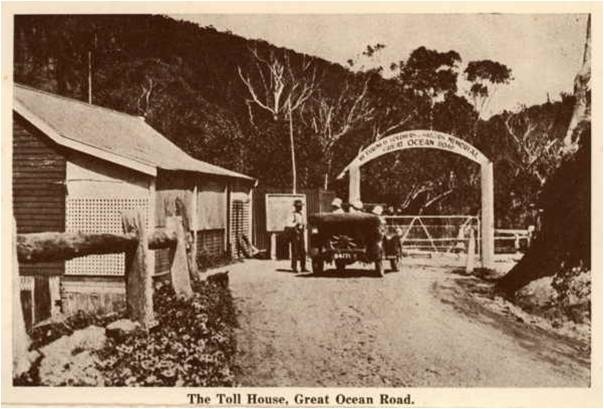
The Great Ocean Road is of historical archaeological significance for its potential to contain features, deposits and/or relics associated with the construction and occupation of construction team campsites and toll booths that will contribute to an understanding of the construction and operation of the Great Ocean Road
Criterion (e) Importance in exhibiting particular aesthetic characteristics.
The Great Ocean Road is aesthetically significant as an iconic tourist route renowned for its scenery. The diverse landscape on the Great Ocean Road has helped to make it one of the most famous tourist drives in the world. The winding road travels through historic seaside resort towns, forest and coastal heath, wetlands and estuaries, cliffs, beaches and rock platforms. It affords views of the limestone coastal cliffs and rock stacks of the western sector of the coastline, particularly the Twelve Apostles, Loch Ard Gorge and Bay of Islands, widely known for their exceptionally high scenic values.
Criterion (g) Strong or special association with a particular community or cultural group for social, cultural or spiritual reasons. This includes the significance of a place to Indigenous peoples as part of their continuing and developing cultural traditions.
The Great Ocean Road is of social significance to the Victorian community as an iconic tourist route in Victoria, which is recognised internationally as one of the greatest coastal drives in the world.
Criterion (h) Special association with the life or works of a person, or group of persons, of importance in Victoria's history.
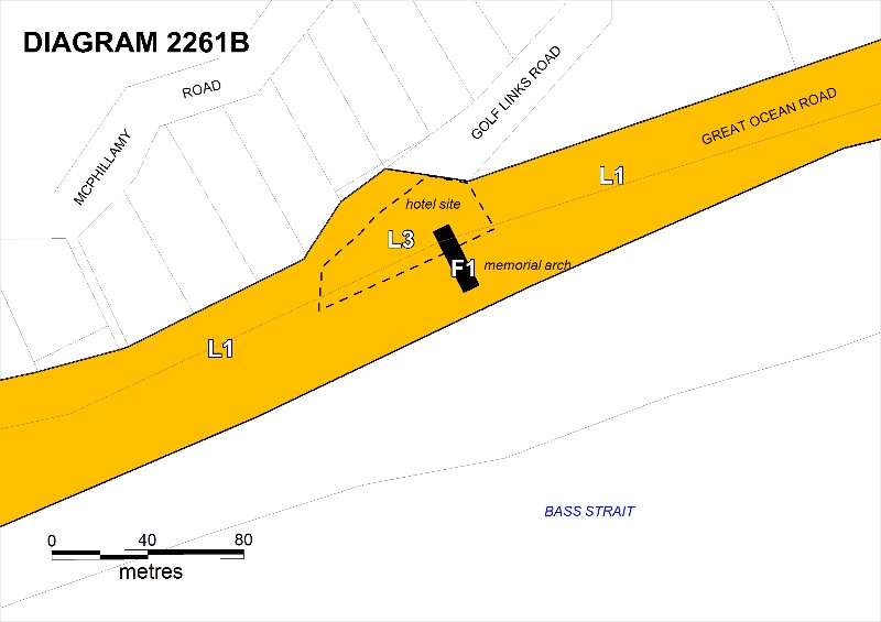
The Great Ocean Road is of historical significance for its association with the returned servicemen involved in the construction and their contribution in opening up this part of the coast. The Road is also of significance for its association with Victorian engineer William Calder, a civil engineer who first suggested the project, surveyor Major William Thomas Bartholomew McCormack who was its supervising engineer, and Geelong businessman, philanthropist and Mayor, Howard Hitchcock who was President of the Great Ocean Road Trust. A memorial plaque is located at The Arch at Eastern View, acknowledging McCormack's role as honorary engineer to the Great Ocean Road Trust.
GREAT OCEAN ROAD - Permit Exemptions
General Exemptions:
General exemptions apply to all places and objects included in the Victorian Heritage Register (VHR). General exemptions have been designed to allow everyday activities, maintenance and changes to your property, which don’t harm its cultural heritage significance, to proceed without the need to obtain approvals under the Heritage Act 2017.
Places of worship: In some circumstances, you can alter a place of worship to accommodate religious practices without a permit, but you must notify the Executive Director of Heritage Victoria before you start the works or activities at least 20 business days before the works or activities are to commence.
Subdivision/consolidation: Permit exemptions exist for some subdivisions and consolidations. If the subdivision or consolidation is in accordance with a planning permit granted under Part 4 of the Planning and Environment Act 1987 and the application for the planning permit was referred to the Executive Director of Heritage Victoria as a determining referral authority, a permit is not required.
Specific exemptions may also apply to your registered place or object. If applicable, these are listed below. Specific exemptions are tailored to the conservation and management needs of an individual registered place or object and set out works and activities that are exempt from the requirements of a permit. Specific exemptions prevail if they conflict with general exemptions.
Find out more about heritage permit exemptions here.
Specific Exemptions:
General Conditions: 1. All exempted alterations are to be planned and carried out in a manner which prevents damage to the fabric of the registered place or object.
General Conditions: 2. Should it become apparent during further inspection or the carrying out of works that original or previously hidden or inaccessible details of the place or object are revealed which relate to the significance of the place or object, then the exemption covering such works shall cease and Heritage Victoria shall be notified as soon as possible. Note: All archaeological places have the potential to contain significant sub-surface artefacts and other remains. In most cases it will be necessary to obtain approval from the Executive Director, Heritage Victoria before the undertaking any works that have a significant sub-surface component. General Conditions: 3.The existence of a Conservation Management Plan or a Heritage Action Plan provides guidance for the management of the heritage values associated with the place. Certain works specified in the management plan may be able to be declared permit exempt by the Executive Director once satisfactory detail has been provided for consideration. General Conditions: 4. Nothing in this determination prevents the Executive Director from amending or rescinding all or any of the permit exemptions. General Conditions: 5. Nothing in this determination exempts owners or their agents from the responsibility to seek relevant planning or building permits from the responsible authorities where applicable.Regular Site Maintenance : The following site maintenance works are permit exempt : a) regular site maintenance provided the works do not involve the removal or destruction of any significant above-ground features or sub-surface archaeological artefacts or deposits; b) the maintenance of an item to retain its conditions or operation without the removal of or damage to the existing fabric or the introduction of new materials; c) cleaning including the removal of surface deposits, organic growths, or graffiti by the use of low pressure water and natural detergents and mild brushing and scrubbing; d) repairs, conservation and maintenance to roads and paths, fences and gates and drainage and irrigation. e) the replacement of existing services such as cabling, plumbing, wiring and fire services that uses existing routes, conduits or voids, and does not involve damage to or the removal of significant fabric. Note: Surface patina which has developed on the fabric may be an important part of the item's significance and if so needs to be preserved during maintenance and cleaning.
Note: Any new materials used for repair must not exacerbate the decay of existing fabric due to chemical incompatibility, obscure existing fabric or limit access to existing fabric for future maintenance. Repair must maximise protection and retention of fabric and include the conservation of existing details or elements.
Fire Management Duties : The following fire management duties are permit exempt: All prevention, preparedness, response and recovery activities, including fuel management and planned burning works in approved agency and municipal fire management plans provided the works do not involve the removal or destruction of any significant above ground features or subsurface archaeological artefacts or deposits. The importance of places listed in the Victorian Heritage Register must be considered when strategies for fire management are being developed. Fire management authorities should be aware of the location, extent and significance of historical and archaeological places when developing and implementing fire management plans and actions.
Signage and Site Interpretation : The following Signage and Site Interpretation activities are permit exempt a) signage and site interpretation activities provided the works do not involve the removal or destruction of any significant above-ground structures or sub-surface archaeological artefacts or deposits; b) the erection of non-illuminated signage for the purpose of ensuring public safety or to assist in the interpretation of the heritage significance of the place or object and which will not adversely affect significant fabric including landscape or archaeological features of the place or obstruct significant views of and from heritage values or items; c) signage and site interpretation products must be located and be of a suitable size so as not to obscure or damage significant fabric of the place; d) signage and site interpretation products must be able to be later removed without causing damage to the significant fabric of the place; Note: The development of signage and site interpretation products must be consistent in the use of format, text, logos, themes and other display materials. Note: Where possible, the signage and interpretation material should be consistent with other schemes developed on similar or associated sites. It may be necessary to consult with land managers and other stakeholders concerning existing schemes and strategies for signage and site interpretation. Minor Works : Note: Any Minor Works that in the opinion of the Executive Director will not adversely affect the heritage significance of the place may be exempt from the permit requirements of the Heritage Act 1995. A person proposing to undertake minor works must submit a proposal to the Executive Director to apply for a s.66 (3) permit exemption for the proposed works. If the Executive Director is satisfied that the works will not adversely affect the heritage values of the site, the applicant may be exempted from the requirement to obtain a heritage permit. If an applicant is uncertain whether a heritage permit is required, it is recommended that the permits co-ordinator be contacted.Road Reserve and Landscape : The following road reserve and landscape works are permit exempt: All works to maintain road safety and the existing roadway, shoulder and drain. Road, shoulder, culvert and kerb repairs and maintenance, drainage works, pavement marking and traffic signs, erection of guard rail and brifen wire, removal of land slips and rock falls, new remedial and stabilisation works and erosion control. Maintenance and conservation of hard landscape features such as paths, driveways, kerbs and gutters, walls and plaques. Construction of standard concrete or gravel crossovers, driveways and paths that are outside the tree protection zone or do not require the removal or lopping of trees and significant vegetation. Vegetation management including slashing and mowing, removal and pruning to maintain road safety and infrastructure clearance, and weed control. Works and management of trees in accordance with Protection of Trees on Development Sites AS4970, and Pruning of amenity trees AS4373. Landscaping and planting to retain a vegetated corridor with indigenous species, and in townships with exotic and/or indigenous species, but excluding important viewing points and vistas. Removal of plants listed as noxious weeds in the Catchment and Land Protection Act 1994.
Townships: The following works or activities within townships are permit exempt:
* All new and reconstruction road, kerb and gutter works, crossovers and driveways;
* Drainage works, pits, culverts and drains;
* Pedestrian crossings, car parks and pavement marking, traffic management works, new street signs, and commercial signs;
* Maintenance of on-road parking surface, edges, kerbing and associated drainage and driveway crossovers; new pavement marking; intersection improvements and/or upgrades and safety treatments; open and underground drainage associated with town stormwater management; road signage, including street names, directional signs, traffic controls signs and promotion signs (eg events or tourist business information signs); town entry signs;
* Vegetation maintenance, including mowing of grass, removal of weeds, and planting of replacement or new vegetation (both exotic and indigenous);
* Footpaths including the local footpath network and some shared pedestrian/bicycle paths forming part of linear path networks, boardwalks, bollards, pedestrian crossings and bridges;
* Street lighting;
* Bus stops and coach parking areas, including shelters;
* Temporary closure of the road for events such as the Apollo Bay Music Festival and Great Victorian Bike Ride;
* Public street furniture including, seats, bollards safety barriers and bins;
* Banner poles/flags;
* Monuments;
* Streetscape features including landscaping, planter boxes, irrigation systems, paving and public art and undergrounding of existing overhead utilities; and
* Occupation of footpath by commercial premises (eg alfresco dining structures and extension of shopfront verandahs over the footpath for weather protection).
GREAT OCEAN ROAD - Permit Exemption Policy
PERMIT POLICY
The purpose of the exemptions is to allow works that do not adversely impact on the cultural heritage significance of the Great Ocean Road.
The ability to maintain road safety should not be restricted by permit requirements, therefore works including removal of land slips, rock falls and maintenance of rock walls, pavement markings, erection of guard rail and brifen wire, signs, road, kerb, shoulder and drain maintenance and vegetation removal outside areas of known or potential archaeological significance are permit exempt.
New works including earthworks and new infrastructure, such as pavement widening, passing lanes, retaining walls, carparks, buildings or structures, bridges or culverts are not permit exempt.
Works in areas that may contain historical archaeological deposits, features and/or relics, such as camp sites require a permit.
Works to the Memorial Arch and the Mount Defiance Lookout plaque require a permit.
-
-
-
-
-
Nirranda Honour Roll (First World War)
 Vic. War Heritage Inventory
 -
Nirranda District Honour Roll (First World War)
 Vic. War Heritage Inventory
 -
Nirranda District Honour Roll (First World War)
 Vic. War Heritage Inventory
-
1 Brockenshire Street
 Yarra City
 -
1 Bundara Street
 Yarra City
 -
1 Forster Street
 Hobsons Bay City
-
-


