| Back to search results » | Back to search page » |
|
Bass River Delta And Flood Plain
LocationBASS VIC 3991 - Property No L10035
File NumberL10035LevelRegional |
|


Statement of Significance
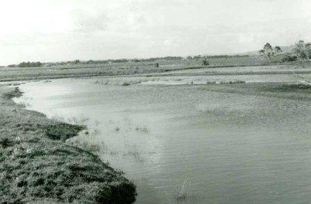
The Bass River delta, as a physiographic unit, extends from Reef Island, an outlier of Tertiary volcanics which is joined to the coast 50 chains to the east by a ridge of basalt rubble, to the Grantville Gravel formation at the foot of the Bass fault scarp in the south. There are a few scattered mangroves, (Avicennia marina var. resinifera) on the coastline south of Reef Island and north of the river mouth. The tidal tract of the river has been successfully colonized by (Spartina), which was planted to stop erosion of the river banks. In 1835, Anderson and Massie, Scots from Launceston, established a station on the Bass River; they used bricks from the settlement abandoned at Corinella in 1828, for their "house". By 1840, they were trading wheat for beef from settlers at Tobin Yallock (Lang Lang) and providing hospitality for those trying to pioneer an overland route into Gipps ' Land. LOCATION: On the eastern side of Western Port, stretching from the above-water section of the delta north-east along the Bass River flood-plain to the township of Bass.
Group
Landscape - Cultural
Category
Other - Landscape - Cultural