| Back to search results » | Back to search page » |
|
POINT NEPEAN DEFENCE AND QUARANTINE PRECINCT
Other NamesEAGLE'S NEST , QUARANTINE STATION , QUARANTINE ANCHORAGE , FORT NEPEAN , FORT PEARCE Location3875 POINT NEPEAN ROAD AND 3880 POINT NEPEAN ROAD AND 1-7 FRANKLANDS DRIVE PORTSEA, MORNINGTON PENINSULA SHIRE
File Number604219LevelRegistered |
|


Statement of Significance
What is significant? A number of Aboriginal sites have been identified on Point Nepean.
These include coastal shell middens which reflect indigenous food
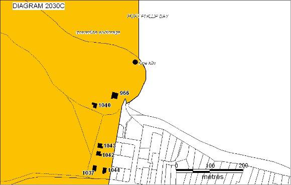
gathering practices over the past 6000 years. The first European use of the land was for grazing and lime burning.
From the 1840s, limeburning became the chief industry in the Portsea
area, supplying lime to Melbourne's building trade. Nepean limestone
was shipped to Melbourne from the late 1830s. Many of the early lime
kilns at Portsea were located along the shoreline. By 1845, a regular
fleet of 20 to 25 schooners carried lime to Melbourne. Large
quantities of local timber were cut to supply the lime kilns, causing
the natural vegetation of banksia and sheoak to become scarce. Two
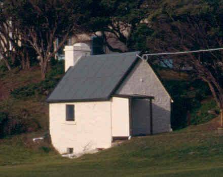
lime kilns are known to remain on the site. The limestone Shepherd?s Hut (c.1845-54) is believed to be a rare
example of employee housing from this period. Although all the fabric
is not original, this may well be of high significance and requires
further investigation. It is possible that only the cellar dates from
1845. The hut was used as a dairy from the 1880s until 1897, and as a
dispensary until 1908. It became the Regimental Sergeant Major's
Office during the Army occupation of the site. Point Nepean contains the oldest surviving buildings erected for
quarantine purposes in Australia. The peninsula was chosen as the
first permanent quarantine station in Victoria because of its early
isolation, access to shipping, deep-water anchorage and security. The
Quarantine Station was constructed from 1852 and operated from the
1850s until 1979. Point Nepean was also used in the management of
infectious diseases within Victoria, housing a leper colony from 1885
to the 1930s, when the surviving patients were transferred to Coode
Island, and a consumptives' colony from the 1880s. Although the
buildings of the leper colony were burnt down in the 1930s, at least
one grave of a Chinese leper patient is in the Point Nepean cemetery. The Point Nepean site housed a remarkable medical complex for its
time. The development of the quarantine station reflected changes in
medical knowledge about infection and the transmission of disease over
the years of its existence and the way major public health issues were
dealt with in Victoria. The arrangements of the hospital buildings
mirrored the class distinctions of the ships bringing passengers to
Melbourne, separating upper class passengers from the rest. The
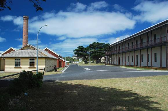
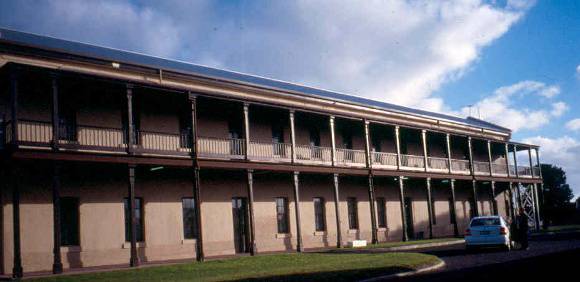
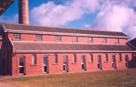
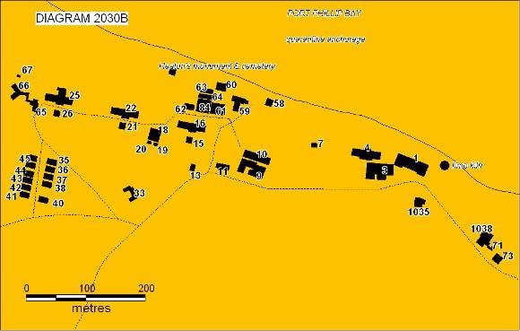
Quarantine Station buildings include: Boatman's Quarters (1888) &
Original Entry Road Alignment, Staff Quarters, Hospitals 2-5
(1858-59), Hospital No. 1 (1917), Kitchen No.2 (1858-59), Kitchen No.
3 (c. 1869) Kitchen No.5(c.1885) , First Class Dining Room (1916)
Administration Building (1916), Disinfecting & Bathing Complex
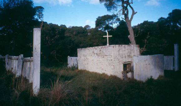
(1900), Isolation Hospital (1916-20) , Cemetery (1852-54) Cemetery
(1854-90) , Crematorium (1892), Heaton's Memorial (1856-58), Isolation
Hospital (1916-20), Matron?s Quarters (1856-58), Morgue and Mortuary
(1921) , Doctor's Consulting Room and Post Office (1913) relocated in
1925 and used as a Maternity Hospital, Administrative Building and
Visiting Staff Quarters (1916-17)and Influenza Huts (1919). The
Influenza Huts housed soldiers with influenza returning from World War
I when almost 300 ships with over 11,800 passengers were quarantined
between November 1918 and August 1919. Other uses of the Quarantine
Station have included the temporary housing of several hundred
children from the Industrial School at Prince's Bridge in 1867. The security of the Quarantine Station was crucial to its function.
Police guarded a forty foot stretch of land between two fences to keep
passengers in and others out of the station. A prefabricated iron
police house was replaced in 1859 by a barracks to house a number of
police sent from other stations to guard the site whenever passengers
were in residence. The single storey timber Superintendent's quarters
were built on the site of this barracks in 1916. Police were then
accommodated in the new administrative complex. There is some evidence
that this 1916 house may contain part of the 1859 police barracks
including a simple symmetrical two roomed cottage with a hipped roof,
similar to the plan of two-roomed hipped-roof police barracks built by
the Public Works Department in several locations in 1859. The police
barracks site is also of archaeological significance. A number of
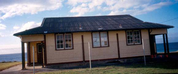
wells and possible cess pits are visible in that area. The Quarantine school (Portsea No. 2929) was located near the east
boundary of the site. The remains have not so far been located. The
school opened in 1889 with about 23 pupils and appears to have closed
in 1894. The site, inside the fences of the Quarantine Station, caused
difficulties when there were patients in quarantine. Some of the
children subsequently attended Sorrento School No. 1090. The Quarantine Station jetty, built in timber in 1859-60, was
demolished in 1973. The cattle jetty was built in 1878. The anchorage
around the Quarantine Station and also that around the Fort Nepean
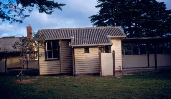
jetty are of archaeological significance. The other staff residences on the site reflect the quarantine and
defence functions. These include the 1899 Medical Superintendent's
house, its size and siting appropriate to his position. The house
retains its stable, which has been converted to other uses. The 1899
house may include elements of the first doctor's house constructed in
1854. The Matron's House was formerly Pike's Cottage, one of three
original stone labourer's cottages built in 1856-58. The Gatekeeper's
House was formerly the Boatman's Cottage built in 1888. Residences
from the early twentieth century relate mainly to the public health
usage of the site such as the four attendants' cottages of c. 1922
near the entrance gate. Their location was well away from the hospital
buildings, perhaps to protect families from infection. Buildings
dating from the period of Army occupation such as the Cadet
Accommodation blocks may not be individually significant but as a
collection illustrate this period of development of the site. A small quarantine cemetery located near the water's edge was used
for the burial of passengers from the 'Ticonderoga' and other early
ships between 1852 and 1854. The Heaton Monument, a 12-foot high
Neo-Egyptian sandstone monument built in 1856-58 still remains at this
site. A new cemetery was established in September 1854, just outside the
Station's western boundary and is now located within the Mornington
Peninsula National Park. Many early settlers were buried in the new
cemetery, as well as sailors from the ships 'Tornado (1868) and
'Cheviot' (1887), wrecked at the Heads. This cemetery was used by
local residents until the General Cemetery at Sorrento was opened to
the public in 1890. In 1952 the surface remains (several stone
monuments and the remains from the Heaton Monument vault), in the old
cemetery were relocated to the new cemetery. The crematorium was built of brick on high ground south of the
Quarantine Station complex. Built in 1892, it is said to have been
primarily intended for the cremation of people who died of leprosy and
is strongly associated with the Quarantine Station operation. In 1951 the Officer Cadet School of the Australian Army took over the
main buildings on the quarantine station site. Very small numbers of
people were quarantined from that time until the official closure of
the Quarantine Station in 1980. A number of new buildings were
constructed c.1963-65 as part of the Officer Cadet School such as a
gymnasium, barracks, library and gatehouse. In 1984 the Officer Cadet
School was relocated to Canberra. The main Parade Ground and Flagstaff
have an historical association with the Officer Cadet School. The School of Army Health replaced the Officer Cadet School from 1985
to 1998. This was the main establishment in Australia for the training
of Army health officers. In 1999 the Quarantine Station buildings were
used to accommodate Kosovar refugees. Point Nepean was a major part of the Victorian coastal defence system
which made Port Phillip Bay reputedly the most heavily defended
harbour of the late nineteenth and early twentieth century in the
southern hemisphere. It is said that the fortifications at Point
Nepean are the best examples demonstrating the development of military
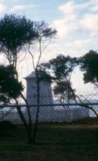
technology of the Port Phillip Bay network. Remaining buildings and
structures from the defence use of the site include the gun
emplacements, light emplacements, observation posts, tunnels, Pearce
Barracks, Fort Pearce, Eagle's Nest, and the Engine House, and a
number of archaeological sites such as Happy Valley, the site of a
World War II camp. The land south of Defence Road was used by the Army
as an operational training ground. Rifle, mortar, anti-tank and
machine gun firing ranges were constructed in this area. The Lewis
Basin was used for field training exercises, as evidenced by the
obstacle course facility built in this area. The Monash Light
navigational aid is located in this area, with a cleared tree/fire
break maintaining an uninterrupted line of vision between the Light
and the navigational beacon located at the western end of Ticonderoga
Bay. This area has had limited disturbance over the past hundred years
because it has been used only for defence activities. The area
contained observation points associated with the fortifications,
observation points for range firing at sea targets and range points
for such firing. The coastline of Point Nepean, on one side of the hazardous entrance
to Port Phillip Bay, has been the site of many wrecks, as ships passed
through the Heads to and from the port of Melbourne. The causes of the
wrecks have included collisions, weather conditions, ignorance of the
hazards of the Rip, negligence, drunkenness, navigational errors and
arson. In December 1967 the Australian Prime Minister Harold Holt
disappeared and was believed to have drowned while swimming in the
surf at Cheviot Beach. There has been a long association between the community and the
defence occupation of the site, in particular, involvement with the
activities of the Officer Cadet School and School of Army Health. The
community holds strong shared memories of experiences and social life
on that land, which have created a strong connection to the place. The
ovals north of Defence Road and west of the Quarantine Station were
used for joint defence-community and local sporting activities. The
areas of community activity were not restricted to the buildings but
included privileged access to various parts of the whole of Point
Nepean. After determining in 1998 that the Point Nepean land was surplus to
Australian Defence Force requirements, Commonwealth Government offers
to return large sections of the land to the Victorian people were
rejected several times by the Victorian Government. The Commonwealth's insistence in 2001 that the Victorian Government
pay the cost of clearing unexploded ordnance from the land on offer
led to a protracted political dispute between the two governments. In April 2002 the Commonwealth announced its intention to dispose of
its land at Point Nepean after a community consultation process to
evaluate future usages. During this process in late 2002 and early
2003, a series of public protests demonstrated widespread community
support for a campaign to 'Save Point Nepean' by keeping the land in
public ownership. In March 2003 the Commonwealth Government agreed to
give 205 hectares of native bushland to the Victorian Government for a
national park, with the Commonwealth paying for the clearance of
unexploded ordnance, and 17 hectares of land at Police Point to the
Mornington Peninsula Shire Council for use as public open space. The remaining 90 hectares of Commonwealth land were offered to the
Victorian Government as a priority sale at market value. When the
Victorian Government rejected these terms, the Commonwealth invited
tenders for a 40-year lease. During the tender period, the National
Trust and the Victorian National Parks Association led a vigorous
protest campaign against the proposed lease. After announcing a
preferred tenderer in October 2003, the Commonwealth said in December
2003 that it had terminated the lease process after failing to reach a
'satisfactory outcome'. At the same time, the Commonwealth declared
that the remaining 90 hectares would be vested in a charitable trust
called the Point Nepean Community Trust with the intention of
transferring the land to the Victorian Government for integration into
a national park within five years.
Why is it significant? Point Nepean Defence and Quarantine Precinct is of architectural
significance for the limestone Shepherd's Hut [c.1845-54] believed to
be a rare example of employee housing from this period. Point Nepean Defence and Quarantine Precinct is of architectural
significance for its quarantine station buildings, a rare example of a
building type and the only example in Victoria. The hospital buildings
of 1858-59 are important examples of Early Colonial buildings, which
are rare in Victoria, and the work of the Public Works Department
architect, Alfred Scurry. The design of the Administration building is
an accomplished example of Colonial Revival architecture, with
planning influences from noted architect, J S Murdoch. The y-shaped
Isolation Hospital (1916-20) is a rare example of a building type with
an exchange room for staff to change their clothes between wards. The
other residential buildings of the later period of construction are of architectural
significance as representative examples of twentieth century
government employee housing Point Nepean Defence and Quarantine Precinct is of outstanding
historical significance for its capacity to demonstrate the historic
use of the site over a long period, from the Aboriginal period to the
most recent use of the land for recreation. Each phase of use has left
evidence in the landscape, in built form, or in archaeological
remains. The shell middens demonstrate the use of the place by
indigenous people. The limestone Shepherd's Hut (c.1845-1854) reflects
the early grazing use by Europeans and the remaining lime kilns, the
limeburning industry. Significant historical archaeological sites are
likely to exist across the whole of Point Nepean, from pre-quarantine
use of the land right through to the defence operations. Point Nepean Defence and Quarantine Precinct is historically
significant in the history of defence in Victoria from its first use
as one of a number of colonial defence installations round Port
Phillip Bay, as an important Commonwealth defence site before and
during the two World Wars and in the latter twentieth century, the
site used for the training of Australian Army personnel at the Officer
Cadet school and the School of Army Health. The staff residences of all periods of construction are of historical
significance in reflecting the quarantine and defence functions.
Buildings dating from the period of Army occupation may not be
individually significant but as a collection illustrate this period of
development of the site. Point Nepean Defence and Quarantine Precinct is historically
significant as the site of many shipwrecks in the nineteenth and early
twentieth centuries, demonstrating the importance of maritime activity
to the development of Victoria. Point Nepean Defence and Quarantine Precinct is historically
significant as the place where Australian Prime Minister Harold Holt
is believed to have drowned. Point Nepean Defence and Quarantine Precinct is an area of high
archaeological significance as the location of early European
settlement in Victoria, which included agricultural and limeburning
activities. Significant historical archaeological sites exist across
the whole of Point Nepean, from pre-quarantine use of the land right
through to the defence operations. Archaeological remains on the
police residence site are particularly important. The defence exercise
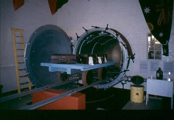
area south of Defence Road and Happy Valley are also of archaeological significance. The Disinfecting and Bathing Complex at the Quarantine Station is of
scientific significance as a rare representative of its type which
became the model for a series of similar complexes around Australia.
The complex retains equipment and fabric which can demonstrate the
history of the control and management of infectious diseases in Australia. Point Nepean Defence and Quarantine Precinct is of social
significance for its recreational use since at least the 1950s when
defence authorities allowed community use and joint defence-community
sporting activities. The part of Point Nepean which has been a
national park since 1988 is of social significance as a tourist
attraction in allowing public access to a unique site of natural and
historic value within Victoria The Precinct is also of social significance because of the sustained
and effective broad based community action involved in having the
entire site set aside as public land rather than being sold to private
interests which was the Federal Government?s original plan.
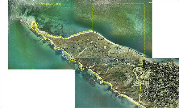
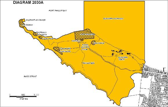
Point Nepean Defence and Quarantine Precinct
at the western extremity of the Mornington Peninsula consists of
approximately 526 hectares of land about 95 km from Melbourne. The
site has an entry from Point Nepean Road, and is partially bounded on
the east by the Portsea Golf Club. At the time of Federation, Point
Nepean was transferred to Commonwealth ownership, although not
gazetted until 1919. In 1988, as part of Australia's Bicentennial
celebrations, 300 hectares were transferred to the State of Victoria
to become part of a new Point Nepean National Park. This park
incorporated the previous Cape Schanck Coastal Park and areas of the
Nepean State Park. From August 1995 the park became known as the
Mornington Peninsula National Park. A large section of land, some
220ha, south of Defence Road, remains in Commonwealth ownership with
no public access due to unexploded ordnance.The Quarantine Station and
Police Point have also been in Commonwealth ownership.
How is it significant?
Point Nepean Defence and Quarantine
Precinct is of archaeological, aesthetic, architectural, historical,
scientific and social significance to the State of Victoria.
Point Nepean Defence and Quarantine
Precinct is of outstanding aesthetic significance for its landscape,
its open space, some avenues and stands of trees, and its internal and
external views. These views include the relationship between bush and
sea, between the buildings and their context, the views across the
Heads to Queenscliff and the Otways, views back towards Melbourne, to
the Bay and from the water to the site, and the 360 degree views from
the narrowest portion of land near the tip of the peninsula.
The Point Nepean site, including the Quarantine Station and the
two cemetery sites and crematorium, is of historical significance in
the history of migration and the history of public health in Victoria.
The Station is historically significant as the first permanent
quarantine station in Victoria and one of the earliest and most
substantial in Australia. It contains the oldest surviving buildings
erected for quarantine purposes in Australia.
Group
Cemeteries and Burial Sites
Category
Cemetery/Graveyard/Burial Ground