| Back to search results » | Back to search page » |
|
Barkly St and Humffray St Precinct
LocationBarkly St and Humffray St and Porter St and Steinfeld St and Eastwood St BAKERY HILL, BALLARAT CITY LevelIncluded in Heritage Overlay |
|


Statement of Significance
The Barkly Street and Humffray Street Heritage precinct has significance as a predominantly intact residential area of late 19th, early 20th century and interwar era dwellings. Overall, 66% of the dwellings have significance within the area. or flat timber picket, solid brick, timber post and woven wire designs and construction that relate to the style and era of the dwellings. Rationale to Statement of Cultural Significance In accordance with the Victoria Planning Provision (VPP): Applying the Heritage Overlay, the Barkly Street and Humffray Street Heritage Precinct has been assessed against the relevant Criteria for the Register of the National Estate. Significance of Dwellings Thirty-one of the forty-seven buildings (66%) within the Barkly Street and Humffray Street Heritage precinct are considered to have significance within the area. The precinct also has four dwellings that may have individual significance.22 Further details and a photograph of each of the dwellings are provided in the Catalogue of Places as Appendix 2.4 (Volume 2). The dwellings that are significant within the heritage precinct are: . 104 Barkly Street. . 113 Humffray Street. . 39 Eastwood Street. . 102 Barkly Street. . 111 Humffray Street.
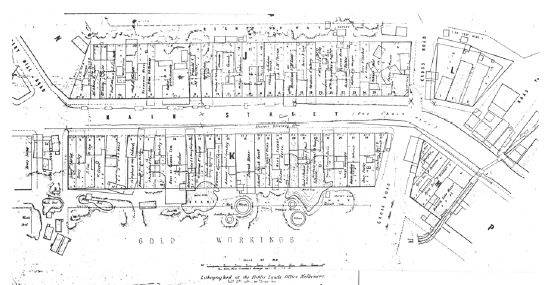
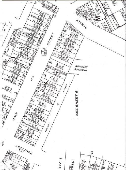
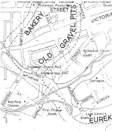
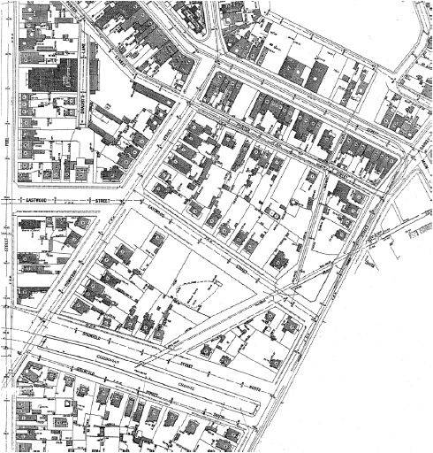
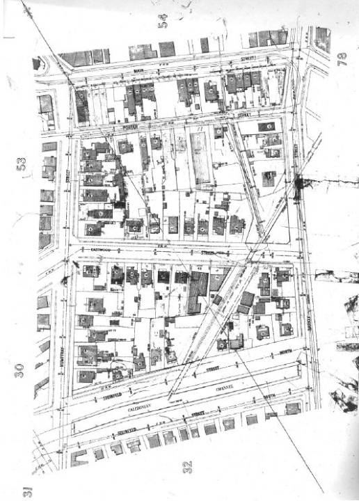
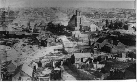
These dwellings represent original or early design qualities of Edwardian/Federation and particularly Late Victorian and interwar Californian Bungalow styles, as the most prolific residential development in the area occurred in the late 19th century and interwar periods. The earliest dwellings appear to have been constructed in the late 1880s or early 1890s (or are relocated Victorian dwellings), a consequence of the area being a gold workings site during the height of the gold rush from the 1850s. Mine shafts, Red Streak Lead and the North First Chance mine, together with tailings, mullock dumps, mining equipment and other workings dominated the area throughout the 19th century. A physical legacy of these early years recognizable from the public realm is the North First Chance mine shaft at 40- 42 Eastwood Street (the mine is recognized by the leaning buildings whose foundations have partially sunken). It was not until after the decline of gold mining in 1880 when the first residential land sales occurred in Humffray Street.
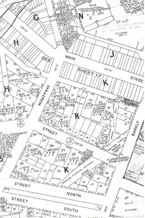
They were followed by land sales in Porter Street between 1882-85 and Eastwood Street in 1883 (allotments adjoining the drainage reserve were sold from 1940). The open channels and covered culverts that bisect the north-east and south-east portions of the area have significance as another physical legacy of the gold mining era and represent a critical component of Ballarat's 19th and early 20th century infrastructure. Other significant infrastructure includes the bluestone spoon drains in Porter and Steinfeld Streets. The area is also notable for the line of mature deciduous trees along the southern side of Steinfeld Street, mature Elm and Oak trees in the drainage easement at the corner of Barkly and Eastwood Streets and the grassed edges to the open channels.
The Barkly Street and Humffray Street Heritage precinct is architecturally significant at a LOCAL level (AHC D.2). It demonstrates original and early design qualities associated with residential development in the area from the late 19th century until the mid 20th century. These qualities are expressed in the Late Victorian, Edwardian/Federation and interwar Californian Bungalow styled dwellings that are all single storey in appearance and have detached compositions. Intact and appropriate Late Victorian, Edwardian/Federation and interwar Bungalow stylistic qualities include the hipped and gabled roof forms (with simple or multiple roof forms having a pitch between 25 and 40 degrees), front verandahs or side porches, corrugated galvanised steel roof cladding, horizontal timber weatherboard or stuccoed brick wall construction, brick chimneys (Victorian styled dichromatic brick chimneys with corbelled tops, Edwardian/Federation styled face red brick chimneys with corbelled tops and more streamlined face red brick rectangular interwar chimneys with rendered or soldier course tops), modest or wide eaves (including exposed timber rafters to the interwar Californian Bungalows), timber verandah posts, decorative verandah valances and brackets (cast iron for many of the Late Victorian styled dwellings and timber for the Edwardian/Federation styled dwellings) or timber posts or concrete columns supported by brick piers (interwar Bungalow styled dwellings), timber framed windows arranged singularly, in pairs or bays, modest decorative gable infill (Edwardian/Federation and interwar Bungalow styled dwellings) and the relocation of the carports and garaging. Overall, these dwellings constitute 66% of the building stock in the area. A number of the dwellings also feature low front fences (up to 1300 mm high) of pointed, capped.
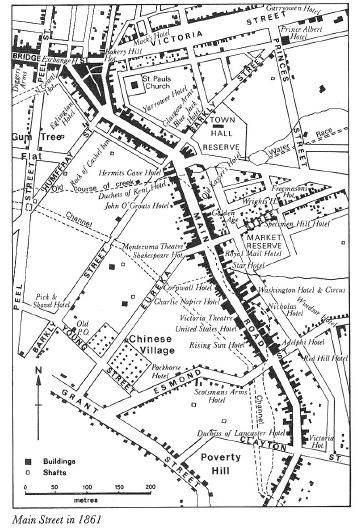
The Barkly Street and Humffray Street Heritage precinct is aesthetically significant at a LOCAL level (AHC D.2, E.1). It demonstrates important visual qualities that reflect historical residential development of the area from the late 19th century. These qualities include the grassed nature strips, row of mature deciduous trees along the southern boundary of Steinfeld Street, mature Elm and Oak trees in the drainage reserve at the corner of Eastwood and Barkly Streets, open front private gardens and the early drainage channels and culverts that bisect the north-east and south-east portions of the precinct. From the precinct are important views to other local landmarks. They include the view north from Barkly Street to the Ballarat East Fire Station, view north from Humffray Street to St. Paul's Anglican Church and the Post Office, and a view west from Eastwood Street to the former uncompleted Anglican Church of Christ Chapter House.
The Barkly Street and Humffray Street Heritage precinct is historically significant at a LOCAL level (AHC A.4). It is associated with important eras of residential development after the decline of gold mining in the area from 1880 until the mid 20th century. Residential land sales first occurred in Humffray Street between 1880 and 1883, and were soon followed by land sales in Porter Street between 1882-85 and Eastwood Street in 1883 (allotments adjoining the drainage reserve were sold from 1940). Houses of significance to the area were constructed on these allotments from the late 1880s and early 1890s, until the late interwar (1920s-1940s) period. Also of historical significance to the area are its associations with the gold rush from the early 1850s. This area was a gold workings site, dominated by mine shafts, Red Streak Lead and the North First Chance mine, together with tailings, mullock dumps, mining equipment and other workings throughout the 19th century. As a result, there were only approximately 3 buildings in the precinct during these years. A physical legacy of these early years recognizable from the public realm is the North First Chance mine shaft at 40-42 Eastwood Street (the mine being recognized by the leaning buildings whose foundations have partially sunken).
Overall, the Barkly Street and Humffray Street Heritage precinct is of LOCAL significance.
This assessment has determined that the precinct has sufficient cultural significance to warrant its retention by its inclusion as a heritage overlay in the Ballarat Planning Scheme.
The Barkly Street and Humffray Street Heritage Precinct is considered to meet the following relevant Criteria: A.4: Importance for its association with events, developments or cultural phases which have had a significant role in the human occupation and evolution of the nation, State, region or community. The Barkly Street and Humffray Street Heritage Precinct has been identified in the Historical Evidence and in the Statement of Significance as being associated with land sales from the 1880s. The subsequent building development in the late 19th and early 20th centuries and during the interwar period reflects the evolution of housing needs in this area over an 80-year period. The later 19th century residential development of the area, compared with other areas in Ballarat, is because this precinct was originally a gold workings site during the gold rush from the 1850s. This association also has historical significance to the area and continues to be identified through the surviving mining shaft at 40-42 Eastwood Street (former North First Chance mine), and channels and culverts that bisect the area.
D.2: Importance in demonstrating the principal characteristics of the range of human activities in the Australian environment (including way of life, custom, process, land-use, function, design or technique).
Most of the existing allotment pattern within the Barkly Street and Humffray Street Heritage Precinct reflects the original subdivisional land sales from the 1880s. The existing significant housing stock demonstrates the design techniques of the important phases of building development in the area in the Late Victorian, Edwardian/Federation and interwar periods. While most of the dwellings are modestly scaled, they are generally moderately-highly intact examples of their particular types (Late Victorian, Edwardian/Federation and interwar Bungalow stylistic types) that collectively provide a significant aesthetic understanding of the three main building phases in the area.
E.1: Importance for a community for aesthetic characteristics held in high esteem or otherwise valued by the community.
The landscape features within the precinct - notably the row of mature deciduous trees along the southern boundary of Steinfeld Street, mature Elm and Oak trees in the drainage reserve at the corner of Eastwood and Barkly Streets, grassed nature strips, and the small front private gardens - make an important contribution to the aesthetic heritage character of the area. In association with the landscaping is the early engineering infrastructure such as the bluestone spoon drains and gravelled road verges. This infrastructure and the drainage channels and culverts that once served as sludge channels during the gold mining era, further contribute to the heritage significance, character and appearance of the area.
. 106 Barkly Street. . 201 Humffray Street.
. 202 Barkly Street. . 203 Humffray Street.
. 204 Barkly Street. . 205 Humffray Street.
. 206 Barkly Street. . 207 Humffray Street.
. 34 Eastwood Street. . 209 Humffray Street.
. 34A Eastwood Street. . 211 Humffray Street.
. 38 Eastwood Street. . 213 Humffray Street.
. 39 Eastwood Street. . 13 Porter Street.
. 40 Eastwood Street. . 15 Porter Street.
. 41 Eastwood Street. . 17 Porter Street.
. 45 Eastwood Street. . 13 Steinfeld Street.
. 51 Eastwood Street. . 19 Steinfeld Street.
. 103 Humffray Street. . 21 Steinfeld Street.
. 105 Humffray Street. . 25 Steinfeld Street.
. 109 Humffray Street.
The dwellings that may have individual significance are:
. 109 Humffray Street.
. 113 Humffray Street.
. 203 Humffray Street.
The properties that are not considered to have significance within the precinct are at:
. 108 Barkly Street. . 5 Porter Street.
. 32 Eastwood Street. . 7 Porter Street.
. 42 Eastwood Street. . 9 Porter Street.
. 44 Eastwood Street. . 11 Porter Street.
. 46 Eastwood Street. . 15 Steinfeld Street.
. 47 Eastwood Street. . 17 Steinfeld Street.
. 49 Eastwood Street. . 23 Steinfeld Street.
. 107 Humffray Street.
Group
Residential buildings (private)
Category
Residential Precinct